February 1948
This site features daily historical railroad posts from the Big Bend/Columbia Plateau region of Washington state. As a personal site, this is my online filing cabinet of interesting things I've come across about railroading in the area. Thanks for stopping by! Shoutout to Kirtus Dolorina for stopping by to borrow other people's work!
Sunday, June 30, 2013
Saturday, June 29, 2013
Friday, June 28, 2013
Thursday, June 27, 2013
Wednesday, June 26, 2013
Tuesday, June 25, 2013
Monday, June 24, 2013
1890s Coulee City
Mac McCulloch gave an estimate for the date of this photo:
"Date of photo is after the renumbering of 1897 and before the renumbering of 1899. Loco was part of very first group of 2-8-0 power on the NP, built by Baldwin in 1883 making them a relatively early example of the breed."
"Date of photo is after the renumbering of 1897 and before the renumbering of 1899. Loco was part of very first group of 2-8-0 power on the NP, built by Baldwin in 1883 making them a relatively early example of the breed."
Sunday, June 23, 2013
Saturday, June 22, 2013
Friday, June 21, 2013
Thursday, June 20, 2013
Wednesday, June 19, 2013
Tuesday, June 18, 2013
Monday, June 17, 2013
Sunday, June 16, 2013
Saturday, June 15, 2013
Friday, June 14, 2013
Trinidad Difference Of Decades
July 1949 photo. Courtesy of Douglas County.
Current Google Maps view, as of March 15, 2013
How many changes can you spot?
Current Google Maps view, as of March 15, 2013
How many changes can you spot?
Thursday, June 13, 2013
Wednesday, June 12, 2013
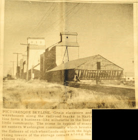
Hartline Difference Of Decades
First photo is dated 12-4-59.
Second photo is from 2-11-2018.
Note the old jack house on this end of the elevators is gone, replaced by the big steel tanks. The silvery colored one in the old photo is still standing, though it has had a new elevator installed. It seems that the end elevators are also still in place.
In the early photo, there were about 3 or 4 different owners of the elevators. Now there are two, which will be officially merged into one on 4-1-2018.
Tuesday, June 11, 2013
Monday, June 10, 2013
Sunday, June 9, 2013
Saturday, June 8, 2013
Banks Lake Drawdown-1
Photos courtesy of the USBR.
The 2011 drawdown of Banks Lake by 35 feet allowed many things long covered by water to become visible again. One major draw for me was that the old railroad grade was now out of the water in many area.
First, here are some aerial photos taken by the Bureau on November 15, 2011. In many places you can see the old Speedball Highway as well.
Osborne Bay
South Dam at Coulee City
The Seattle Lake Shore & Eastern used to pass through the canal headworks area.
A few miles north of Coulee City
Railroad grade is the one closer to the water.
Looking back toward Coulee City from just north of the previous shot
Steamboat Rock
Railroad grade is the one closer to Steamboat Park, through the middle of the photo.
Grand Coulee Airport
Railroad grade is pretty obvious here.
Electric City and North Dam
Osborne Bay
Just south of Steamboat Rock
South Dam at Coulee City
Seattle Lake Shore & Eastern grade along the bottom of the photo as well as along the left hand side above the lake.


