Showing posts with label Them Dam Writers. Show all posts

Friday, September 9, 2022

From Bridge To Building-The GN Marcus Bridge Today

Slide show I wrote up for the Great Northern Railway Historical Society annual convention in Nelson, BC. 

The as-built view of the bridge at Marcus over the Columbia River. The bridge was constructed in 1901 entirely of wood. Marcus was where the line from Spokane split, with one branch going on to Grand Forks, Oroville, and eventually Vancouver, BC. The other branch went along the Columbia River, crossed into Canada, and eventually ended at a place called Nelson.


Ice floes and high water along the Columbia in February 1929 severely damaged two spans. During the floe, pier number 5, near the center of the river, started to move downstream during one of the worst ice jams yet experienced in the river at that point. The pier continued to move a few inches a day, until it had gone downstream 22 feet and had settled 20 feet on one corner. The spans were badly twisted when the movement of the pier finally stopped.

Plans called for a new bridge 100 feet upstream from the old structure. Three of the wooden spans would be retained, a fourth wooden span would be rebuilt, and three new steel spans of 225 feet each would be used. 

A short timber approach would be required on the south side, and a trestle approach 700 feet long would be required on the north side


During March 1930, during the construction of the new bridge, fire broke out and soon both bridges were burning. Losses at the time were estimated at $150,000. Three wooden spans had just been moved into place from the old structure, all of which were consumed. One new steel span dropped into the river. The trestle approach on the north side burned. The small fire fighting crew from Marcus were joined by forces from Orient and Colville. The new bridge was supposed to have reopened within a week.


The GN mustered it's forces and completed the bridge in by April 1930. Shortly after the new bridg opened, spans of the old bridge were dynamited out of the way. 


John Barriger III took this photo of the bridge in 1939, looking north. Notice the the approach and fill on the far side.


John Barriger III took this photo as well, looking south towards Marcus proper. Notice the two wooden spans on this end of the bridge. 


The caption on the bottom reads: “Air photo of the old and new Marcus, looking northward (NE). At a point above the southern part of old Marcus (in the lower right of the photo), the evacuation town is seen below the bench on which new Marcus is developing. Long street in center is Main Street. Lower long line on hillside at right is the new highway in the building and above, the new railroad.


Eric Jacobson sent along this photo, possibly taken around 1938 or 39, of his grandfather and his stepfather on the bridge.


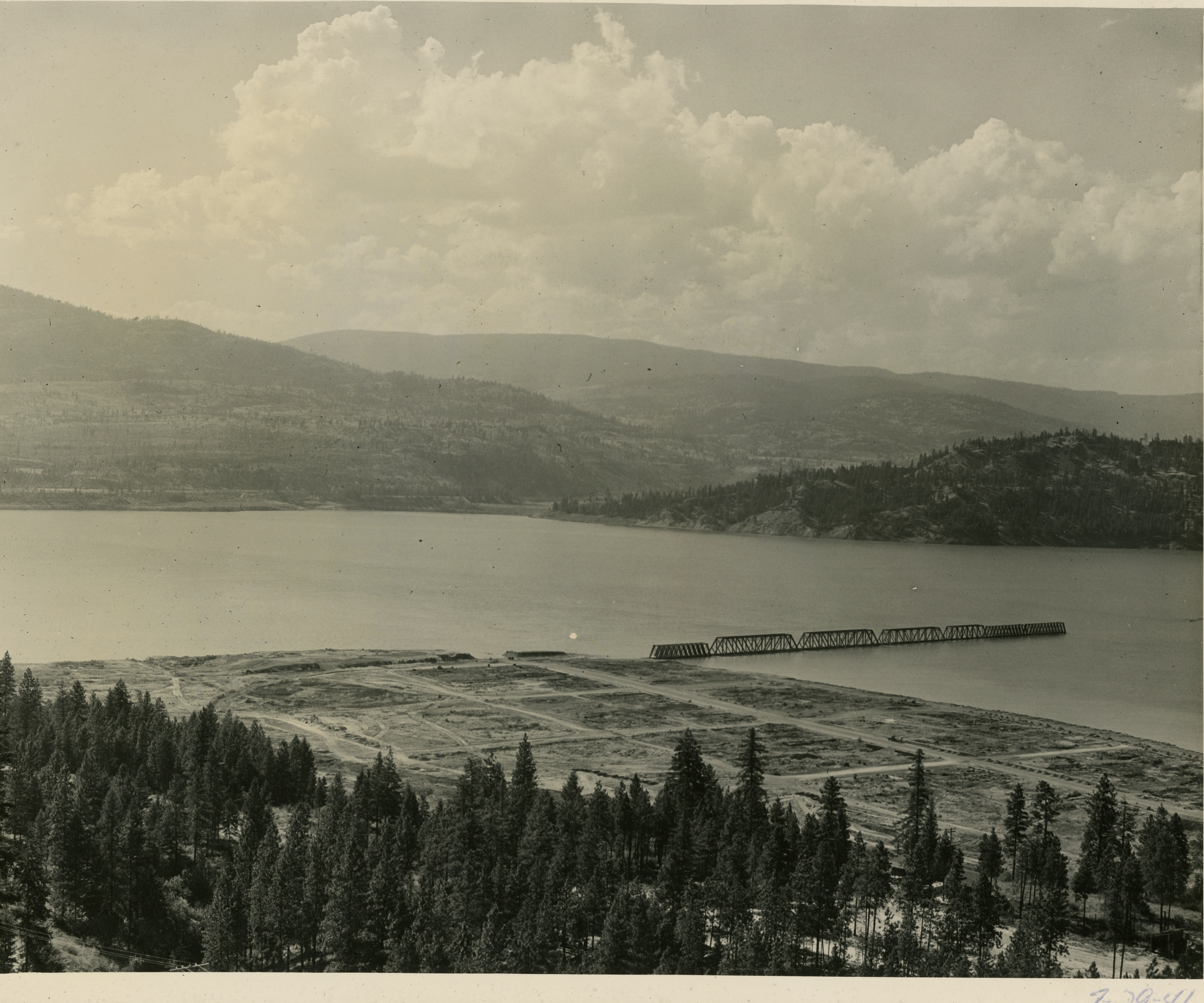
Springtime runoff on the Columbia River was being impounded by a rising Grand Coulee Dam downstream, with the result being the river rose to an unprecedented height at the time of this photo, on July 29, 1941. By now the entire town has been removed and the bridge is being inundated.


Another July 29, 1941 view of the bridge, this time from water level. All the rail has been removed and the trestle and fill approach on the far side are under water.


Water has receded in this February 1942 view. Approaching the bridge from the left is the powered barge “Paul Bunyon” which is pushing another barge in front of it. You can see the north approach from the bridge again above the water level, as well as part of the grade and wye in the foreground. Why is this happening? A severe building material shortage is gripping the nation, and these sections of bridge are going to be salvaged for building projects around Grand Coulee Dam.


Things are getting interesting here. The empty barge is being partially sunk, to fit under one of the spans. The Paul Bunyon will push it into place. In the meantime, workers will be loosening any fittings tying the span to the pier.


Water is pumped out of the barge, lifting it and the span of the bridge. Note the high water mark of the water on the bridge. 


One span is on it's way to Grand Coulee! Pushing this time are the boats “Camp Ferry”  and  “Blue Ox.” Every section of the bridge was removed this way. In fact, the GN realized it needed to retain one of the sections and paid the Bureau of Reclamation $10,000 for it. It was used at the bridge at Waneta, where there was a crossing of the Pend Oreille River. 


March 1942 marked the final part of the bridge removal, detonating the remaining piers. Twelve hundred pounds of powder were used to blast one of the Marcus bridge piers loose from its foundation. The water spout is about 40 feet high from the water level. Most of the powder in this shot was about 35 feet below the water surface.


Bridge removing operations continued just up the Kettle River from Marcus. Here we see a June 1942 view of the Paul Bunyon again with a barge being placed under a bridge section near Boyds.


Same scene as the previous slide.


Floating the sections were a bit more tricky on the Kettle River. Not seen in this view is the Paul Bunyon holding the barge in place while the tugboat “Nespelem” helps navigate around a bend.


Just a bit further down the Kettle from the last view, we can see the the Paul Bunyon anchored behind a spit of land while the Nespelem continues to turn the bridge section.


Both the Nespelem and Paul Bunyon move a bridge section under the new railroad and highway bridges at the mouth of the Kettle River.


Same as previous.


Now clear of the Kettle River, the Paul Bunyon is used to better turn the barge in the growing body of water and the confluence of the Columbia and Kettle Rivers.


Satellite view of the bridges over the Kettle River confluence with the Columbia River today.


A smaller section of bridge is being moved just downstream from the new railroad over the Kettle, about 2 1/2 miles north from the confluence with the Columbia, and about 1/2 mile south of where the old bridge crossed.


Satellite view of where the new bridge seen in the previous view was located.


The smaller section of bridge previously seen moving into the open water of the Columbia River at the Kettle River confluence.


A larger bridge section arriving behind Grand Coulee Dam. The Paul Bunyon is pulling while the Camp Ferry is on the opposite side of the bridge.


Closer view of the bridge section and the Paul Bunyon. Part of the town of Grand Coulee can be seen in the distant right side.


A bridge section has been beached and will soon be building material. In the background is the town of Grand Coulee.


One bridge section is being taken apart.


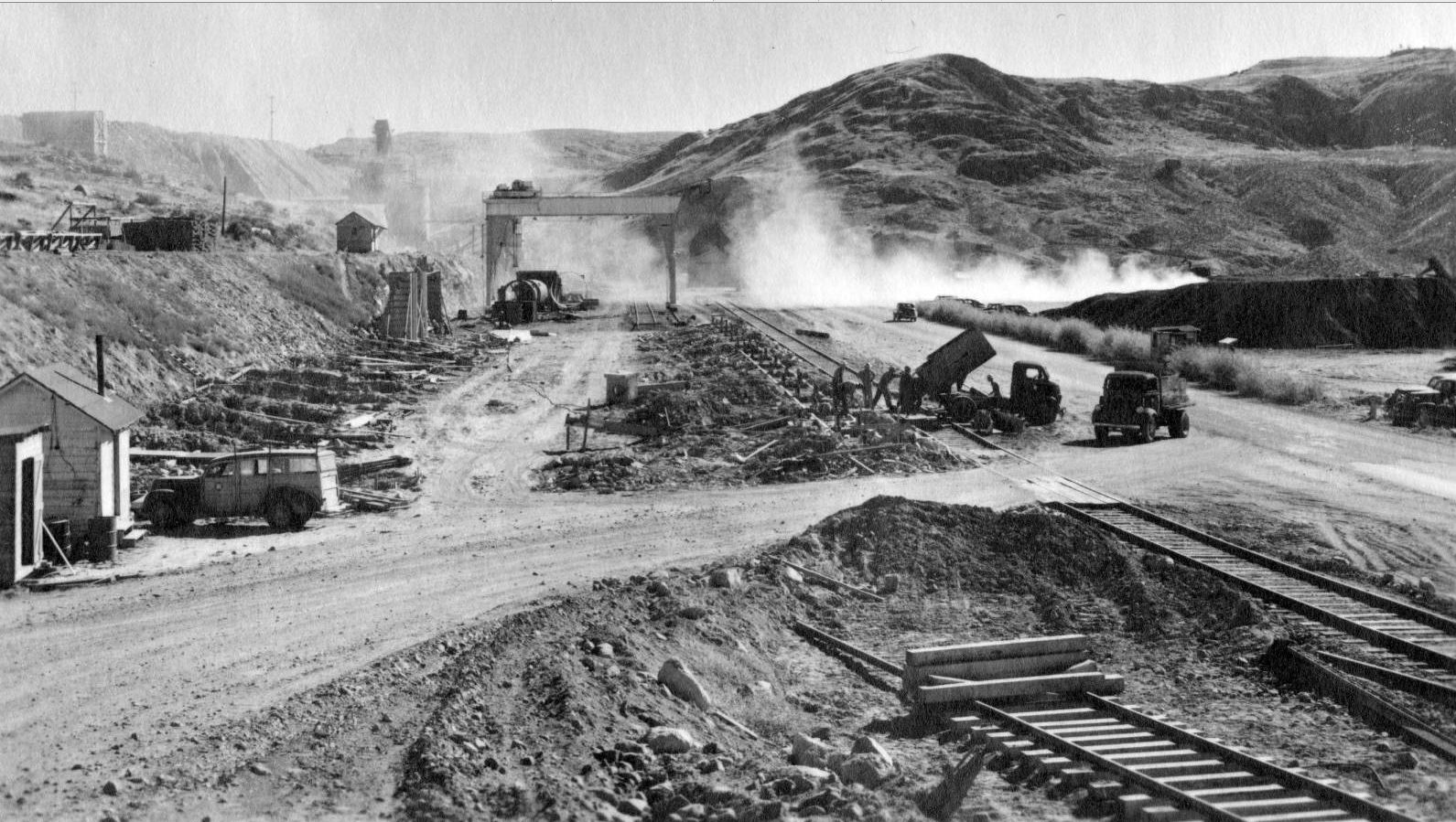
This is the site of the cement unloading facilities just southwest of the Grand Coulee Dam site. Note the tracks in the background. The need for a large building to hold material for construction will be built here.


The site for what will be known as the Assembly building is being prepped. The cement tanks can be seen through the dust on the left of the 75 ton gantry crane, which had been relocated from the Electric City yard.


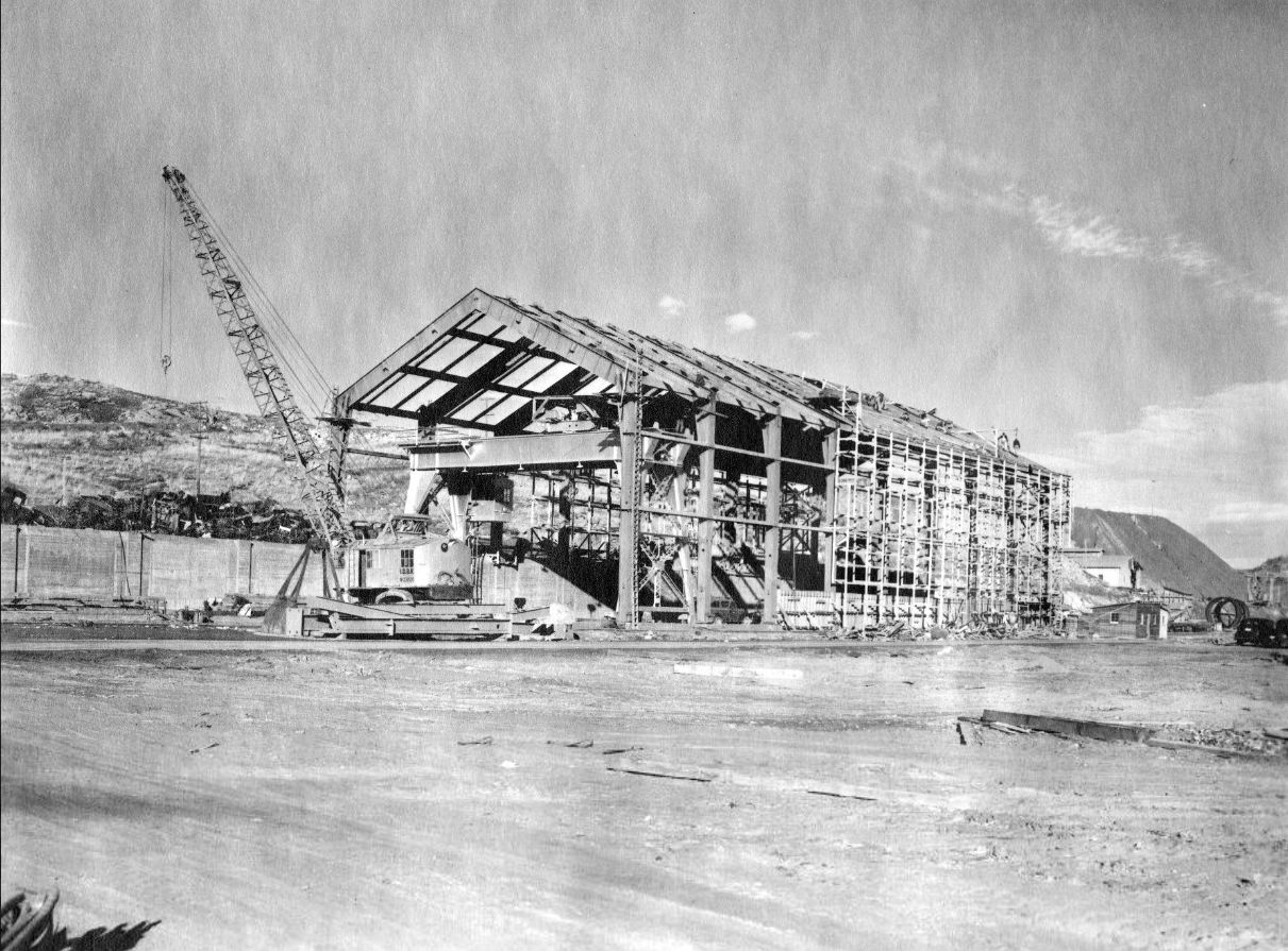
The first of the trusses are going up for the Assembly Building. Reclamation engineers notes that “columns in Bents 1, 2 and 15 are made of small members (19" deep) from 225' bridge” and “columns in bents 3 to 14 inclusive are made of large members (21" deep) from 253' bridge.” The walls are about 45 feet tall, the width about 77 feet, and is 355 feet long. The gable of the roof is 65 feet above grade.


The building is nearly complete. You can see the bridge girders all along the roof supports. The gantry crane previously seen is now part of the interior of the building. 


The opposite side of the building. Note how the cement tanks are now gone. The road in the bottom of the view leads to the dam toward the right.


View of the completed building. Note it's proximity to the completed Grand Coulee Dam.


Current view of the building. Most of the other buildings in this view are newer construction. Thanks to John Kemble for snagging the photo.


Where the building sits today in the industrial complex that supports the dam. SR 155 curves around the right side of the site.


Other buildings constructed with salvaged bridge material material no longer stand. Some started to be torn down in the 1960s. This building once stood near where the current visitor's center is. It too had bridge members as trusses. 


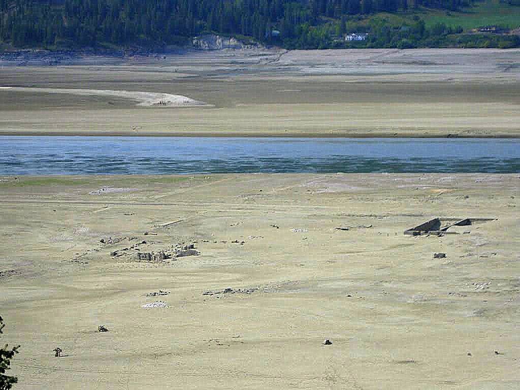
A look back at Marcus in 2011 when the water behind Grand Coulee Dam was lowered considerably, the northern approach to the old Marcus bridge popped out of the water. Many foundations of the old town can be seen regularly even today.


Satellite view of what the Marcus townsite normally looks like today. The railroad can be seen as the line through eh trees below the yellow line of SR 25.


Of the 2 current trusses of the bridge over the Pend Oreille River at Waneta, are either one from the Marcus bridge?


Tuesday, June 14, 2022

Moses Lake Carp Prized In New York City Homes

From the Spokane "Chronicle."

April 8, 1931


Moses Lake Carp Prized In New York City Homes

1931

During the early days of the Great Depression, Fish hawkers in New York shout their wares in husky voices and gentlemen of commerce stop to admire the great delicacy-and buy. While far across the continent from New York, in central Washington, fishermen drag huge nets through a silver lake and large ugly looking fish, carp, are seined by the ton.

Once in the hands of the fish vendor their unsightly skins removed, they become a delicacy. Every year the Milwaukee Road  hauled gigantic refrigerator cars loaded to hilt to points east via fast express trains, where they were quickly handed off to eastern railroads for markets like New York, hungry for this delicious fish.

Moses Lake, with its then 105-mile shore line of beautiful orchards and fertile farm lands, makes it truly the oasis of the Columbia Basin Project.

During a high-water period some years ago, Moses lake broke through the sand hills and connected up with the Columbia River. When the waters receded, the lake found itself well stocked with carp. These fish multiply very rapidly and had it not been for the Minnawash Fish Company conceiving the idea of using them for commercial purposes, the fish could never have attained their present size.

Nets from 1400 to 1500 feet in length were used in seining the fish, which are then put into large boats and towed by motor to fish ponds made up for this purpose. There they are fed and fattened for the market.

In 1927 922,347 pounds of carp were shipped over the Milwaukee to points in the east.

Carp is not a game fish, and not being of a spectacular type, wasn't very well known to angler. However, it was not uncommon to see hundreds of people fishing for carp along the shore and nearly every one is rewarded with a good catch. 

The most common bait used was a dough ball made by boiling corn meal to a good stiff mash, then working ordinary cotton batting into it until it becomes hard and stiff, adnd then rolling into little round pellets about the size of a marble.

Serious carp removal projects have continued over the years, including a tournament held a few weeks ago. The largest known specimen to have been removed from the lake weighed just shy of 50lbs.

Friday, June 18, 2021

Grand Coulee Super Dome

Article I wrote for Them Dam Writers.

The Chicago, Milwaukee, St. Paul & Pacific, also known as the Milwaukee Road in later years, was always an innovator in the railroad field. A notable accomplishment was the electrification of its mainline tracks through the Rocky Mountains and Cascade Range. Electric locomotives of the 1910s were far superior to steam engines of the period. 

Why are speaking about the Milwaukee Road, when the line didn't operate anywhere near the Grand Coulee area? Their mainline bypassed Spokane many miles to the south, though there was a branchline to the city. The main route continued west via Othello, then over the Saddle Mountains to Ellensburg, continuing over the Cascades to Tacoma. 

Digging into the details of how cement came to Grand Coulee leads one to find out how the Milwaukee Road was deeply involved. Recall the dam project would take a lot of cement, enough so that six plants in the Pacific Northwest were engaged to provide it, via boxcar, to the dam site. One was on the branchline from Spokane to Metaline Falls, the Lehigh Portland Cement. Lehigh had an enormous output of cement, providing more than any of the other five plants. All of this traffic was hauled by the Milwaukee to Spokane before turning over the cars to the Northern Pacific for further hauling to Odair, then to the dam. 


Having this traffic was important enough to the Milwaukee Road that after World War II was over, their marketing department saw an opportunity, as the other area railroads did, to note that Grand Coulee Dam was an engineering marvel and did what they could to tout it as one of the wonders of the world. To that end, images of the dam popped up in advertising, postcards and even playing cards.

Postwar passenger service on US railroads was a time of booming ridership, with most every railroad putting on new streamlined cars with sleek, new, diesel locomotives. In an effort to outdo the competition, a dome-topped passenger car was developed by the Chicago, Burlington and Quincy Railroad (CB&Q) in 1945. They took a regular streamlined coach and built a smaller upper level that featured 24 seats positioned lengthwise in a glass domed section, allowing the view of the passing scenery to be seen from all directions, versus the 46 seats remaining in the lower section. 


This new car was an instant hit and soon the CB&Q had long-distance trains featuring no fewer than five dome cars per train. Soon every railroad that had generous overhead clearances had dome cars. In the early 1950s, the Milwaukee took note of a newly designed car from the Pullman-Standard Car Manufacturing Co. It featured dome along the full 80-foot length of the car. This allowed seating for 80 people 15 1/2 feet above the rail in the dome, and 28 below in the lower level. The Milwaukee signed up for ten of these cars, labeling them “Super Domes,” which were delivered in 1952.

Because of that large amount of glass, the car needed a very powerful air conditioning system, which took up a portion of the lower section. Included in the car was a small kitchen, making the car an even stronger selling point in that drinks and light refreshments could be served.

Because of that need for non-passenger space in the lower level of the car, a thick partition was constructed to help drown out the sounds of the mechanical equipment. To help spruce up the interior, the prominent architectural photography firm of Kaufman and Fabry of Chicago was hired. The partition was decorated with a lighted pictorial mural in full color, furnished and installed by Kaufman. This mural, with special Luminator lighting, had the appearance of a picture window frame without glass, the frame being painted the partition wall color. One car had a photo of Grand Coulee Dam.


The exterior paint scheme consisted of the traditional Milwaukee orange and maroon colors with black underbody. Included was the running Hiawatha Native American character logo, a Milwaukee trademark, complimenting the name of the train running between Chicago and Tacoma, the Olympian Hiawatha. 

The Olympian Hiawatha was discontinued in 1961, and six surplus dome cars were sold in 1964. The remaining cars eventually were passed on to Amtrak and still survive today, fully restored to its original look, though not with the Grand Coulee Dam picture inside.

The photo of the interior of the car was taken by John Barriger III, a prominent railroad president, who liked to spend his time off riding the named trains of other railroads. He would usually ride in the end car and take images of the passing towns and scenery along numerous lines, including the Great Northern in Washington State. He toured on the Milwaukee Road numerous times and his large photo archive, now part of the St. Louis Mercantile Library in St. Louis, Missouri, is now the home to all of his images, including this featured one.

Wednesday, February 17, 2021

Bacon Siphon And Tunnel

Written by me, Dan Bolyard.
 
Part of the scheme to get irrigation water from the Columbia River was to pump it into the upper Grand Coulee by the pump-generators at the dam site. Water would flow into the equalizing reservoir, now named Banks Lake. From there the water would flow two miles through a canal blasted out of basalt. The next section is the focus of this essay: the Bacon Siphon and Bacon Tunnel, built in 1947.

The name Bacon comes from an old station midway on the Northern Pacific Adrian Cutoff, which ran south of Coulee City to the Great Northern siding at Adrian, a distance of about 25 miles. The odd name's origin is unknown, though one local legend has it there was a run on food at the local general store after the area was opened for homesteading. At one point the only remaining foodstuff left in the place was Bacon. I like the idea that it was named for someone, though I have yet to find conclusive proof either way. .

The siphon and tunnel are actually closer to Coulee City, so the reason for the choice of the Bacon name for the project is unknown to me, though it is distinctive, and unlikely to be confused with any other named location in the project of canals and siphons downstream.

The siphon was the tool used to cross part of the upper reaches of the lower Grand Coulee, namely Don Paul Draw. The project name for the draw is Bacon Coulee. Odd to me is that pioneer settler Dan Paul lived at the very tip, closest to town, so the choice of Don or Bacon just confuses it.

The siphon was to take water from the two-mile main canal, via a 22-foot diameter concrete pipe, with the higher end receiving water at a higher elevation, and then dumping the water into the tunnel at a slightly lower level. There was a modest amount of excavation in the draw/coulee to allow for a smooth flow of the pipe. Once that was done, a metal frame was built in sections, then a form was built before concrete was poured. When finished the siphon was 1,038 feet long.

The Bacon tunnel is of greater interest to me. The area is made up of various lava flows, so the tunnel would have to be blasted through basalt, a lava rock. The rock cools into a large crystalline shape and is difficult to drill through. The tunnel was planned at 10,045 feet long. The contractor, C.E. Connolly, established a siding near the south portal of the tunnel, along the NP branch, aptly named Connolly.

The Connolly camp featured the usual buildings, tents for the men, an air compressor enclosure, an office, a tool sharpening shed, and dynamite storage. In order to remove the spoil from the tunnel, a short section of railroad track was built.

The tunnel was built in the usual style of drilling, blasting, and muck removing. When enough of the 22-foot diameter tunnel was completed to full size, it was lined with concrete. Photos show two sets of tracks exiting the south portal at one time, with later photos showing only one. Small gas-electric locomotives worked the line. the spoil being dumped along a short distance from the portal.

In the photo, we are looking out the north portal on August 5, 1947. The track for the mucking crew is very evident, with a scoop on a railroad car seen on the left. Across Don Paul Draw/Bacon Coulee, a blasted rock is being removed from where the beginning of the siphon will be.

The completed siphon and tunnel were rated for carrying 7.250 cubic feet of water per second. Water demand was so great a second siphon and second tunnel were completed in 1976.

The photographer is unknown, likely a staff photographer from the Bureau of Reclamation. The photo is part of the collection of the Coulee Pioneer Museum in Electric City.


Wednesday, September 30, 2020

Progress Being Made On Dam

Article I wrote for Them Dam Writers.

One yardstick to apply to the progress being made on Grand Coulee Dam was taken during a snapshot in May 1936. It was based on the tonnage handled by the railroad built for the purpose to move materials and equipment from Odair, near Coulee City, up the upper Grand Coulee, and then down the hill to the dam site. The story in the facts and figures was discussed in the MWAK “Columbian,” the house organ of the general contractors. It read as follows:


An oil burning Shay that backs down a 5 percent grade had a great part in moving the 162,000,000 net pounds that came in by rail by April 1. That meant a gross tonnage of 290,000,000 pounds for 2087 cars used.


A locomotive made daily trips from the mainline at Odair, 31 miles away, to Electric City. The low-geared Shay continued the additional five miles to the government warehouse by swinging wide about curves and along the cutbacks of high abutments.


From the cement silos to the warehouse yards is two miles, about 4000 feet as the crow flies. Up and down this grade, the Shay creeps along at the rate of from eight to ten mles per hour. This gear-driven engine is used in place of a road locomotive becasue the steep grade requires it.


Since the first use of the Shay on July 23, 1935, the month of March has taken over a lion’s share in monthly railroad work as 23,641 net tons, or 48, 316 gross tons, came into Electric City on 530 cars and 561 empties were returned. Tonnage for March was four times the 550-ton average for each month of the railroad operations in 1936. January and February were next highest in order with 16, 077 and 14,380 tons.


The explanation lay in the increaced cement shipments of 25 cars daily, with 72,000 pounds per car net; the 3,000,000 feet of timering arrived during the last two months and the 187 carloads of steel for the concrete-carrying trestles.


The 2087 carloads brought in meant 962 cars of bulk cement for the cement silos, and the 1125 of miscellaneous, such as timber, steel and explosives. Cement itself, both bulk and sack, reached 70,000,000lbs since the beginning of work.


The 120,000 net tons that had passed over the railroads represented 55 percent of all tonnage checked by the company warehouse, even though in the 21 months of receiving material, the railroad had only been in operation 8 of them.


Transportation equipment consisted of two engines, the road locomotive and the Shay. The road locomotive was built for the Southern Pacific Railway in March 1903. It was purchased by MWAk on July 29, 1935. The road locomotive had been in operation for two and a half months at the time of the article. It was making a daily trip to Odair, leaving at 5am and returning at 10am. The engine weighed 135 tons and was capable of carrying 3500 tons per train, or about 50 carloads of cement, the amount required at the peak of operations. It was derelict and out of service in 1937, likely due to age, and was scrapped at the dam.


The 80-ton Shay, was built for the Charles R. McCormick Lumber Co. as their #200, on May 27, 1926. This logging line had operations located around Quilcene, WA. It was purchased by MWAK on January 28, 1936. It operated from Electric City to the government warehouse, transfered materials about the yard at Electric City, unloaded, reloaded and carried them for the dam site whenever needed. It’s capacity was 5 cars downgrade and 5 empties up. It was always placed on the downgrade side of the cars it was moving, so it backed down the hill to lead it’s loads, in order to keep the high point of water around the firebox, making a boiler explosion less likely. This engine was scrapped at the dam in 1949.


The line did not sport a turntable to turn the locomotives. It did have a number of switchbacks in order to get down to the level of the warehouse near the river. From there material was trucked to wherever needed.


Train service and maintenance took place during the second shift only, using 30 men. Track was kept up by two section crews, each with six men and a foreman.


The storage yard at Electric City was used because of the lack of a suitable space at the dam site proper. The yard had more than adequate space, being 4,000 feet long and 200 feet wide. Loads were spotted about the yard over three lines of track.


Two cranes took care of loading and unloading heavy materials, one a locomotive crane with a 50-foot boom; the other a 75-ton gantry crane. Also in the yards was a repair shop and a steel bending machine, where reeinforcing steel, as for concrete, was cut and shaped. In the yard were stored much structural steel, pipe, machinery, timber, bridge steel, piling and other bulky materials.


Transportation equipment, with the exception of the cars that actually carring the materials, belonged to the company and was at it’s disposal. With the railroad owned by the government, the lines would be taken over by the government on the completion of the dam.


The shay is pulling empty cement boxcars through the cut at the northeast end of Grand Coulee. This area later became the back entrance to the USBR Grand Coulee Project Office and Industrial Area. Photo courtesy of the Coulee Pioneer Museum.


The former Southern Pacific engine, repainted to honor Governor Martin for the first official train to the dam, is now out of service and being prepped for scrap, after having been worn out after many years of heavy use. Photo courtesy of the EWU Hu Blonk archive.


Wednesday, March 4, 2020

David H Ryan Vs State of Washington

Article I wrote for Them Dam Writers.

October 1936

David H. Ryan, one of the early contractors at the Grand Coulee dam site operations, brought suit against the state of Washington, seeking a refund on taxes imposed on his successful bids on the projects he worked on. The first case he brought was based on the tax assessed upon the total amount of sales of merchandise made by him and also upon the total amount of gross income he received from completing a Federal government contract, all within the area comprised of the Columbia Basin project. The tax to be rejected in the second case was based upon the total amount of gross income received by him during his second contract, building the construction railroad. Ryan questioned whether the state of Washington had any jurisdiction within the territory of the project, sufficient to permit the state to impose and collect an occupation tax for services rendered by Ryan to the Federal government.
On November 29, 1933, Ryan, a resident of San Diego, California, entered into a contract with the United States for excavation activities at the dam site for the sum of $534,500. The specifications provided, among other things, that he should obtain all required licenses and permits, should give preference -- after ex-service men -- to citizens who were residents of the county and state in which the work was to be performed, should furnish compensation insurance in compliance with the laws of the state wherein the work was to be done, and should comply with all applicable provisions of Federal, state, and municipal safety laws and building and construction codes.
Ryan started the first contract about January 1, 1934 and completed it that summer. During the entire contract, he maintained his office and living quarters within the area of the project.
After the completion of the first contract, Ryan, on July 18, 1934, entered into a second contract for the construction of a railroad to the dam site, for $235,570. The railroad was to be 34.5 miles in length, extending from the Northern Pacific tracks at Odair, to the dam site. The specifications for this contract contained the same provisions as the first. Ryan lived for about half of the time during the second contract at Coulee City, outside of the territory of the project, and for the rest of the contract, he was at the dam site on government land.

On July 16, 1934, two days before the start of Ryan's second contract, the US entered into a contract with Silas Mason Company, Inc., and others, for construction work on the dam and power plant, for $29,339,301.50. This contract did not include any of the work to be done by Ryan.
The contract of Silas Mason Company, Inc. is referenced as it grew out of an action similar to Ryan's suits, Silas Mason Co. v. State Tax Commission. Mason's claim that he shouldn't have to pay the tax, and Ryan's similar claim, were tried in superior court at the same time and all the evidence was applied to all three cases. They lost and the three further appeals were argued in the court on the same day, using records containing identical statements of facts.

The specifications attached to the contract of Silas Mason Company, Inc., provided that the contractor set up with the state and county authorities for schools, and that police protection would be furnished by the Washington State Patrol in cooperation with the Federal government, but that the contractor should provide a jail.

During the time that the construction work was in progress, the US acquired the land that formed the area of the project. One condemnation proceeding stated that a particular tract was acquired by the US around May 14, 1934, after Ryan had commenced work. Included in the project area are school lands of the state and also tribal lands, all of which had been taken over by the Federal government.
During the period of the construction work under his first contract, Ryan maintained warehouses on ground within the project and at the dam site, where he stored and sold gasoline, oil, tires and automobile accessories. He paid the state a tax on these sales, the recovery of which forms a part of the basis of his first action.

At its regular session of 1933, the state legislature passed an act known as the Occupation Tax Act. The act related to certain business activities "within this state." At its special session of 1933, the legislature amended to apply to all business activities "within this state," which became effective January 18, 1934, shortly after Ryan’s first contract had been awarded. His complaint is that his contracts constituted sales of services, within the provisions of the act, in connection with the proceeds of his contracts, which he felt were exempt from the tax. He felt the state had no jurisdiction, as this was a Federal project.

Article I, Section 8, clause 17, of the constitution of the United States, as interpreted by the courts at the time, provided that Congress shall have power: "To exercise exclusive legislation in all cases whatsoever, over such district (not exceeding ten miles square) as may, by cession of particular states, and the acceptance of congress, become the seat of the government of the United States, and to exercise like authority over all places purchased by the consent of the legislature of the state in which the same shall be, for the Erection of Forts, Magazines, Arsenals, dock-Yards, and other needful buildings.”

The provision of Art. I, Section 8, clause 17 is that there are two ways in which lands within the jurisdiction of the state may become subject to the exclusive jurisdiction of the US: (1) By purchase by the United States for certain specified purposes, with the consent of the state, and (2) cession of exclusive jurisdiction to the US by the state.

By interpretation over a number of years, the term "needful buildings" had been applied to the following: a navy yard, a military hospital, a military reservation, an army training and mobilization station, a customs house, locks and dams, a post office, a penitentiary, an Indian training school, a military cemetery, a soldiers' home, and a courthouse.

Next, the state gave its consent to the acquisition of lands for sites of locks, dams, etc. The term "needful buildings" was deemed broad enough to include locks and dams. It is very probable that specific mention of locks and dams was made in the statute in order to remove any doubt of the provision.

This was not a contest between the Federal government and the state as to jurisdiction. It was a contest between the state, asserting its jurisdiction, and an individual who asserts that exclusive jurisdiction rests in the Federal government. The governments were working together, and recognizing each other. The Federal government furnished the money, supervised the work, and maintained the operation of the project. The state furnished a large amount of money for the preliminary work and then, through the Columbia Basin Commission, acted in an advisory capacity to the Federal government. The state also had an option to take over the entire project when completed.

In so far as the legislative acts in question were concerned, they held authority upon the business activities of Ryan and Silas Mason within the project. The tax had to be paid.

Monday, January 27, 2020

The Railroads Survey To The Dam

Article I wrote for Them Dam Writers.

Preliminary surveys for a railroad to the Grand Coulee Dam site were made in 1933 by both the Northern Pacific Railway (NP) and Great Northern Railway (GN). 

The NP considered a $700,000 extension from Odair, a siding located about two miles from Coulee City, and running up the floor of the upper Grand Coulee. The GN considered extending the branch line from Mansfield. Their million-dollar extension would have gone over the plateau up near Leahy where the survey branched. One line then went down Barker Canyon to the dam site. The other went down Foster Creek to the Columbia, then down the east bank of the river to the damsite. The thinking for this longer line was it would give them not only a chance for the construction traffic, but also the future agricultural tonnage from the fertile bench lands along the river.

The GN had resurveyed the Mansfield extension, and had the means to start construction at a moment's notice, if it received the go-ahead. It had previously surveyed to the river in 1909.
Senator Clarence Dill had asked the NP to build to the dam, though he knew of the readiness of the GN.

A further plan, which was announced at a joint conference in Coulee City in September 1933, stated that both roads would build a joint line up the floor of the coulee. If this were to happen, the GN would use the Washington Central branch (an NP line) from Adrian to Coulee City, where the new line to the dam site would start.

The NP extension was seen as satisfactory; consequently, they applied for a permit to build. The permit was granted by the Interstate Commerce Commission on February 13, 1934; however, when the NP asked for exclusive franchise rights, they were denied by the State Department of Public Works, and so then the NP abandoned the project, but knew it would still retain the bulk of the traffic to be handed off at Odair.

Thereafter the Government decided to built its own railroad, and immediately engaged the NP to locate a line from Odair to the head of the Grand Coulee, this being substantially the same route which that company had formerly located.

The GN came to an agreement with the NP to simply allow an exchange of loads at Adrian, freshening an old agreement dating back to 1903.

The location survey was completed in May, and thereafter all engineering work was transferred to the Bureau of Reclamation. Two engineering sections were established, No. 1 covering the first seventeen miles and No. 2 the last eleven miles. A contract for construction of the railroad was awarded to David H. Ryan, who started work on August 9, 1934, and thereafter the section engineers with their field surveying crews were in constant service on the railroad project. Considerable surveying was involved on Section No. 2 in mapping lands at the railroad terminus which were to be used for storage yards and a proposed steel-rolling site.    

Newspaper clipping showing the general layout of the GN vs NP lines and their proposed extensions to the dam.
Final construction of the line to the dam, as surveyed by the NP and built by government contractor.
  

Older map showing the 1909 GN line surveyed out to nearly Rex. The line to Leahy would have been built if the GN had been given permission, then on to the dam.