This site features daily historical railroad posts from the Big Bend/Columbia Plateau region of Washington state. As a personal site, this is my online filing cabinet of interesting things I've come across about railroading in the area. I know it's easy to grab an image from here and post it elsewhere, like Steve Renfrow does, but if you do, could you at least give this site a little credit? Dan Bolyard
Sunday, February 28, 2021
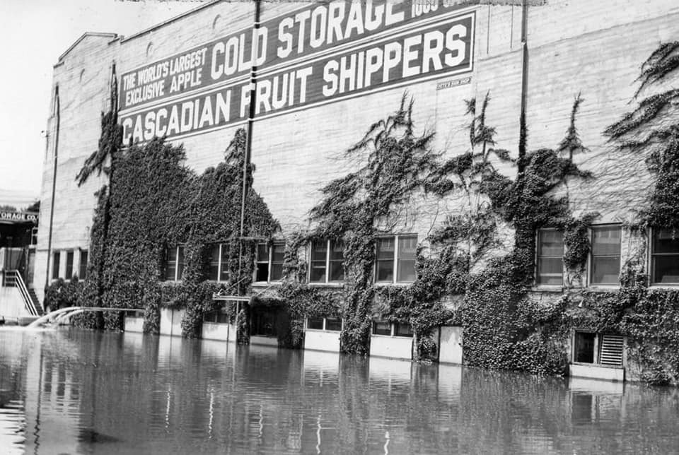
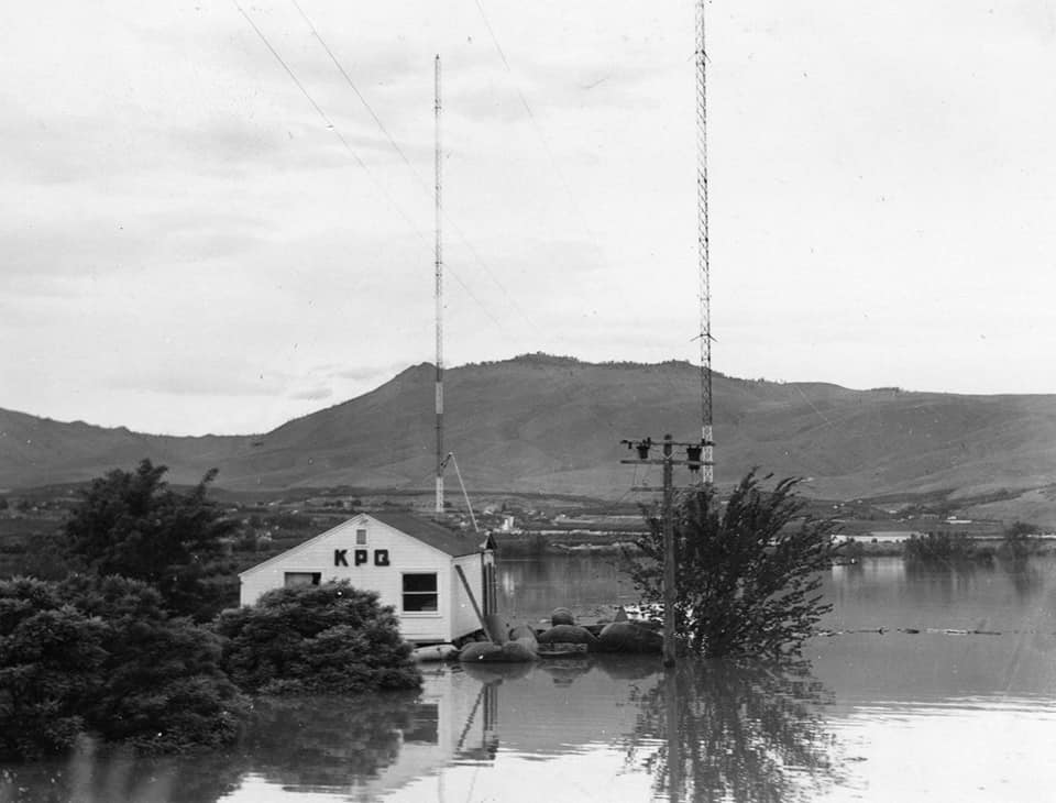
May 1948 Flood Views
A pet research project of mine has been the impact of the flooding of May and June 1948 on the area. Recall that water completely washed out the Waterville Railway.
Anyway, one of the stories I had read was the water over Rock Island Dam covering a large part of the structure. A photo from Ebay arrived today which displayed the extent of the water. A companion newspaper clipping shows the same scene from the air.
Included is a view of Grand Coulee Dam on May 30, 1948, showing the torrent of water over the top.
Through the help of others, I got a picture of the Thurston Street underpass in Wenatchee showing the high water that encompassed part of downtown Wenatchee.
Water spilling over Rock Island Dam.
A newspaper clipping showing the same.
Thurston Street underpass high water marker.
Fifth Street underpass.
"The flow at Rock Island was high enough there was not gross head the run the plant so it was shut down. As a result of this the Federal Power Commission ( the predecessor of the Federal Energy Regulatory Commission) ordered the PUD to develop another source of hydro power that did not depend on the Columbia river. This is what led to the study of the Wenatchee project. A plan that involved three dams on the upper Wenatchee river.
"The 1948 flood also wiped out all long distance telephone communication. Rock Island dam had a circuit that used the high voltage transmission line. It was the only communication between eastern Washington and the coast and was turned over to the state patrol for emergency use."
Beebe bridge area photos:
Saturday, February 27, 2021
Friday, February 26, 2021
Thursday, February 25, 2021
Wednesday, February 24, 2021
Tuesday, February 23, 2021
Monday, February 22, 2021
Sunday, February 21, 2021
Saturday, February 20, 2021
Friday, February 19, 2021
Thursday, February 18, 2021
Wednesday, February 17, 2021
Bacon Siphon And Tunnel
Written by me, Dan Bolyard.
Part of the scheme to get irrigation
water from the Columbia River was to pump it into the upper Grand
Coulee by the pump-generators at the dam site. Water would flow into
the equalizing reservoir, now named Banks Lake. From there the water
would flow two miles through a canal blasted out of basalt. The next
section is the focus of this essay: the Bacon Siphon and Bacon
Tunnel, built in 1947.
The name Bacon comes from an old
station midway on the Northern Pacific Adrian Cutoff, which ran south
of Coulee City to the Great Northern siding at Adrian, a distance of
about 25 miles. The odd name's origin is unknown, though one local
legend has it there was a run on food at the local general store
after the area was opened for homesteading. At one point the only
remaining foodstuff left in the place was Bacon. I like the idea that
it was named for someone, though I have yet to find conclusive proof
either way. .
The
siphon and tunnel are actually closer to Coulee City, so the reason
for the choice of the Bacon name for the project is unknown to me,
though it is distinctive, and unlikely to be confused with any other
named location in the project of canals and siphons downstream.
The
siphon was the tool used to cross part of the upper reaches of the
lower Grand Coulee, namely Don Paul Draw. The project name for the
draw is Bacon Coulee. Odd to me is that pioneer settler Dan Paul
lived at the very tip, closest to town, so the choice of Don or Bacon
just confuses it.
The
siphon was to take water from the two-mile main canal, via a 22-foot
diameter concrete pipe, with the higher end receiving water at a
higher elevation, and then dumping the water into the tunnel at a
slightly lower level. There was a modest amount of excavation in the
draw/coulee to allow for a smooth flow of the pipe. Once that was
done, a metal frame was built in sections, then a form was built
before concrete was poured. When finished the siphon was 1,038 feet
long.
The
Bacon tunnel is of greater interest to me. The area is made up of
various lava flows, so the tunnel would have to be blasted through
basalt, a lava rock. The rock cools into a large crystalline
shape and is difficult to drill through. The tunnel was planned at
10,045 feet long. The contractor, C.E. Connolly, established a siding
near the south portal of the tunnel, along the NP branch, aptly named
Connolly.
The Connolly camp featured the usual
buildings, tents for the men, an air compressor enclosure, an office,
a tool sharpening shed, and dynamite storage. In order to remove the
spoil from the tunnel, a short section of railroad track was built.
The tunnel was built in the usual style
of drilling, blasting, and muck removing. When enough of the 22-foot
diameter tunnel was completed to full size, it was lined with
concrete. Photos show two sets of tracks exiting the south portal at
one time, with later photos showing only one. Small gas-electric
locomotives worked the line. the spoil being dumped along a short
distance from the portal.
In the photo, we are looking out the
north portal on August 5, 1947. The track for the mucking crew is
very evident, with a scoop on a railroad car seen on the left. Across
Don Paul Draw/Bacon Coulee, a blasted rock is being removed from
where the beginning of the siphon will be.
The completed siphon and tunnel were
rated for carrying 7.250 cubic feet of water per second. Water
demand was so great a second siphon and second tunnel were completed
in 1976.
The photographer is unknown, likely a
staff photographer from the Bureau of Reclamation. The photo is part
of the collection of the Coulee Pioneer Museum in Electric City.
Tuesday, February 16, 2021
Monday, February 15, 2021
Sunday, February 14, 2021
Saturday, February 13, 2021
Friday, February 12, 2021
Thursday, February 11, 2021
Wednesday, February 10, 2021
Tuesday, February 9, 2021
Monday, February 8, 2021
Sunday, February 7, 2021
Saturday, February 6, 2021
Friday, February 5, 2021
Thursday, February 4, 2021
Subscribe to:
Posts (Atom)


