

The substation is located near Vernita on the Columbia River Northwest of Richland. Due to the substation being in the middle of a desolate area, the Bonneville Power Administration (BPA) erected a small community adjacent to the substation for construction workers, substation operators, and maintenance personnel. It was complete with family housing, a dorm for single workers, a fire station, post office, and a school. The first housing was completed in 1942 with an additional 13 residences added later. Trees, flowers, and other landscaping was added as well. The substation also provided power to the Hanford site for the top secret Manhattan project.
Due to automation of the substation in the late 1980's, there was no longer a need to house workers on site. The small community was removed and the landscape was returned to a desert environment.
Neal L. adds:
"I discovered this region in 1982 as a boy. I began researching it's history & prehistory in 1991. This is an excellent photo and shows many things. It says,"Jan.1945,(shadow of Umtanum Ridge confirms winter, also indicates mid-day with no clouds to the south). Western aspect, high quality film, 200 ASA or higher,(military) from an airplane 1500'-2000',(military). The photo isn't classified or it's security classification has been cut away.
"The debris pile, lower right is from const. of Midway as well as material from removal of Mr. Terrell's Juniper Springs Ranch. It's outta frame left,( the only structure not razed was a small concrete/cobble stone building, likely the blacksmith shop?) This is where many Pioneers retreated to during the largest flood on record in June, 1894.
"Midway with housing, the untaking tower, switchyard, and control building/head quarters, fallout shelter below. Just inside Umtanum's shadow, 1000' west is Vernita(1906-1943). It had a Post Office and ranch with a sizable orchard. If you turned north the Richmond Ferry(1906-1943) was about a mile. It crossed at Col. Rivermile 390&391.(The road jct. there is 3.0 miles from gate 126 at SR 24).
"In 2017 I made a "Historical Location Sign" an placed it there at the Vernita townsite. The rail line was completed here in 1914. Fruit here in the Upper Priest Rapids Valley ripened 7-10 days before any other locations in the Pac. N.W. That combination made the fruit harvest here the most profitable. West is the New York Ranch,, a large orchard. The Paris Ranch was down and across the Columbia at R.M. 386.5.
"Across the skyline, L to R you can see Cairn Hope Pk., 3354' it holds snow, as shown here, longer than anywhere in the region. It's part of Yakima Ridge. Next is an extra thick cluster of mid-level clouds held there by Mt. Rainier, elev. 14,410 and W.N.W. at 95 miles distant. Today, at 3.6 miles west of SR24 the road ends.
"The 8' elk fence, orchard, and everything west is owned by S. Martinez Livestock Inc. LLC (may well be a "Century Farm"?) If memory serves it began with Simon Martinez and one band of sheep in the 1920s? Today the Martinez Family is one of the most highly respected ranching/farming operations in the Pac. N.W. They're award winning stewards of the land, leading by example, and following the "Golden Rule". We'd be a much better nation if our govt. would follow suit."

Guest post by Allen Miller.
There seemed to be some interest generated in the Hanford Branch from my story about working in Beverly. The branch was constructed for 46 miles south, down the west bank of the Columbia River in 1912-13, the branch opening for service officially on May 16, 1913, but businessmen in Ellensburg were given a special sneak preview of the branch when a special train, known as the "Trade Extension" excursion was operated out of Ellensburg on Tuesday, May 6, 1913. In the hopes of selling business lots in the towns of White Bluffs and Hanford, and developing a growing fruit industry in the newly-irrigated Priest Rapids Valley this special train consisted of locomotive # 7500 a class C4 Consolidation (2-8-0) that was formerly Montana Railroad # 101, built by Baldwin Locomotive Works in October, 1904. Also a baggage car, day coach, sleepers "Ellensburg" and "Spokane" and business car # 5004, assigned to Columbia Division Superintendent Mott Sawyer. The train ran to Othello, where lunch was served in the Interstate beanery in the depot. The train then doubled back to Beverly and ran down what was then called the Priest Rapids Line to White Bluffs where the train spent the night. It continued to Hanford on the morning of the 7th and returned to Ellensburg about 6 o'clock that evening.
The Milwaukee Road then offered special excursion rates to White Bluffs and Hanford to the general public for the first week of the lines opening, with return limit on the following week. The line never warranted more than mixed service when it came to passengers, meaning that a passenger car was carried on the rear of the local freight to accommodate passenger service. The train was nicknamed the "Beverly Sage Hen" by the local railroaders, but was also given the moniker "Sagebrush Annie" by the residents of Priest Rapids Valley. Every fall the sleepy branch would come alive with a supplement added to the current employee timetable and increased train size as carloads of fresh fruit were brought up the branch to be expedited on main line trains for eastern destinations. Peaches the size of grapefruits were described, other products included apples, cherries, pears, watermelons, cantaloupe and grapes.
The nation entering into World War II in 1941 would bring big changes to the modest little branch. On March 6th, 1943 the railroad and residents of the Priest Rapids Valley were served notice that they had one month to evacuate the premises because the U.S. Government was taking over the area for a military reservation. The government purchased and took over 25 miles of the southern end of the branch, establishing a sizeable interchange yard at the station of Riverland, which was designated Hanford Yard. Practically overnight the traffic grew on the line. Beverly yard was expanded in size from 2 to 5 tracks and an addition was built onto the east end of the Beverly depot to accommodate the dozen or more clerks brought in to process the billing and associated paperwork. It was not uncommon to have trains of 100 cars going down the branch with every commodity imaginable as building materials were needed to house the hundreds of workers hired to build the facility. Shipments of ice were brought in ordinary boxcars with water running out of them. One wondered how much ice was left when it got to it's destination.
The plutonium was made here for Trinity, that tested the first atomic bomb near Alamogordo. Also for the bombs dropped on Nagasaki and Hiroshima that brought an end to the war. Surprisingly, to keep from drawing attention to what was going on, the plutonium was transported in a small box container on an ordinary passenger train. No spectacular special runs like with the silk trains of an earlier era. The Hanford Project was one of the best kept secrets of World War II. Throughout the 1950's and 60's plutonium was produced during the Cold War. For these shipments of plutonium and spent uranium oxide the Hanford Local crews would get a midnight call about once a month, to run light engine to Hanford Yard and pick up a baggage car accompanied by two guards. This car was nicknamed the "Bomb Car" and was set out on the east end of the house track at Beverly for pick up by the passenger train. The Hanford Local during these years originated out of Othello, ran to Beverly and on to Hanford, then tied up at Beverly the rest of the week and returned to Othello on the weekend. The annex added to the Beverly depot in 1943 was converted to a bunkhouse for the Hanford Local crew during their extended layover.
By the time I worked at Beverly the Hanford Local was run "as needed" and mostly hauled transformers and other equipment to the Midway substation at Vernita, which was a regulating station for electricity produced from the Grand Coulee dam. Milwaukee's newest power did make a run or two on the Hanford Branch, I have a running order for MP15AC # 471.
Crowd from the Trade Extension excursion outside the Othello depot, May 6, 1913, soon to depart for a two-day tour of the new Priest Rapids Line.


Courtesy of the Bureau of Reclamation.
Formerly accessed by the Milwaukee Road Hanford branch. Note a few views still have rail visible. This spot is now isolated from the national rail network.


Overall, the Storage Building retains integrity of location, design, setting, materials, workmanship, feeling, and association, despite its movement to a different location within the substation property and modifications to the entrance. The building contributes to the historic character and significance of the Midway Substation and is recommended as a contributing resource to the substation district for its association with BPA’s Master Grid development. The resource does not convey sufficient historic significance to be eligible as an individual historic property. The Midway Substation, part of BPA’s master grid development, was constructed near Vernita in Benton County, Washington, in 1941 to serve the Northwest Electric Company and Washington Water Power Company interchange (BPA 1941:73).
The Midway Substation is a key distribution point to Puget Sound, Hanford and eastern Washington. It is notable for delivering power to the Hanford Atomic Works and as a key element for linking the Bonneville and Grand Coulee dams into a single system (DAHP 2011). The power enabled wartime production of plutonium, thereby facilitating development of the nuclear fission bomb deployed against Nagasaki, Japan in August 1945 (Lally 2009). According to BPA internal data, BPA acquired the Midway Substation site on January 1, 1941. The Washington Department of Archaeology and Historic Preservation (DAHP) determined the Midway Substation eligible for listing in the National Register of Historic Places in 2011 (DAHP 2011).
The Midway Substation, along with the Walla Walla and Spokane (Glenn H. Bell) substations, was designed for quick development to accommodate pressing wartime power needs (Daily Capital Journal 1941). The funds allocated for the Midway Substation’s initial construction were part of a $7 million appropriation for BPA grid system completion (Statesman Journal 1941). By mid-December 1941, defense industry applications for power “jumped to an all-time high,” according to administrator Paul J. Raver. Raver emphasized the “government’s policy of long-time planning to meet future power needs enables us to meet the war emergency. We already have completed or have under construction at Walla Walla, Midway, Spokane and several other points, substation facilities which can be rapidly expanded” (Oregonian 1941a). Alan Yonker of Portland submitted the low bid of $151,788 for construction of the substation’s “operator’s cottages, dormitory and garages” (Oregonian 1941b).
In 1944, BPA had installed 230-kV line terminal facilities at Midway Substation for the Hanford No. 1 and No. 2 transmission lines, and was in the process of constructing a second 230-kV transformer bank (BPA 1944:57). The line was designed to increase stable power transmission to the Portland and Puget Sound areas (Oregonian 1944). In 1951, BPA added a third transmission line between Grand Coulee and the Midway Substation. The new 105-mile “steel tower” line was estimated to cost $4 million and would initially transmit power at 190-kV, with an increase to 250 kV the following year, thereby relieving overload on the two existing lines between Grand Coulee dam and the substation (Idaho Statesman 1951). In 1958, BPA awarded Witzig Construction Company of Corvallis, Oregon, a $74,681 contract to construct 230-kV Priest Rapids terminal additions at Midway Substation. The Bend Bulletin reported that, “Work calls for grading, fencing and surfacing the switchyard addition, excavating for and constructing foundations and erection of multiple deadend structures and equipment.” The Midway Substation additions permitted BPA to integrate power from Priest Rapids dam into the “Northwest power pool” and transmit Priest Rapids power to other northwest utilities (Bend Bulletin 1958).
Storage buildings are found at many BPA substations as part of general operations during all eras of BPA’s development. Constructed circa 1956, the Midway Storage Building (approximately 320sq. ft.) sits on a slab-on-grade concrete foundation and is constructed out of standing-seam metal panels with a flat roof finished with standing-seam metal and a metal ventilator. The primary elevation faces north toward the Switchyard and consists of a single-door opening with a flush-paneled metal door and a rectangular metal louver to the west. The west elevation includes an opening with a flush-paneled hatch door above a projecting metal shelf. The south elevation consists of a metal vent hood and small metal louver. The east elevation is comprised of a single-door opening with a flush-paneled metal door. The interior of the Storage Building includes a finished concrete floor, exposed paneled metal walls and ceiling, caged light fixtures, and a small crane on a steel I-beam. Moderate alterations have occurred since the building’s original construction, according to a field investigation completed June 29, 2017 as well as an analysis of aerial images and historic documentation. Changes that have been made include it being moved from its original location to its existing location circa 1981 (BPA Aerial 1981), the removal of its second roof ventilator and capacitors (date unknown), and the creation of the hatched opening and metal shelf (dates unknown).
Bend Bulletin. 1958. “Contract Award Made to Firm.” July 30. Bonneville Power Administration (BPA Aerial). Various dates. “Aerial photos 1954-2007.” Copies on file at Bonneville Power Administration of Multnomah County, Portland, Oregon. Bonneville Power Administration (BPA). “2016 Facility Condition Assessment,” VFA Facility Database, 2016. https://facility.vfafacility.com/facility/frameworks/main.jsp. Accessed 5/11/2017. Bonneville Power Administration (BPA). 1939. Second Annual Report of the Administrator of the Bonneville Power Administration. United States Department of the Interior. Bonneville Power Administration (BPA). 1941. Annual Report of the Administrator of the Bonneville Power Administration to the Secretary of the Interior. U.S. Department of the Interior. Bonneville Power Administration (BPA). 1944. Annual Report of the Administrator of the Bonneville Power Administration. U.S. Department of the Interior. BPA.gov. 2017. About Us. Electronic Document, https://www.bpa.gov/news/AboutUs/Pages/default.aspx (accessed March 29, 2017). Curran, Christine Ann. 1998. Master’s Thesis. A Historic Context for the Transmission of Hydroelectricity by the Bonneville Power Administration, 1939-1945. University of Oregon. Daily Capital Journal. 1941. “Raver Orders Speed-up In Line Building.” December 17. Department of Archaeology and Historic Preservation (DAHP). 2011. Midway Substation. Property ID 102474. Historic Property Report. Holstine, Craig and Gloria J. J. Lenz. “Bonneville Power Administration Master Grid Discontiguous Historic District.” National Register of Historic Places Registration Form. Washington, D.C.: U.S. Department of the Interior, National Park Service, 1986. Idaho Statesman. 1951. “Third Power Line Will Strengthen Northwest’s Pool.” December 28. Kramer, George. 2010. Corridors of Power: The Bonneville Power Administration Transmission Network. Historic Context Statement. For the Bonneville Power Administration, Portland, Oregon under Master Agreement #38010. April. Kramer, George. 2012. Bonneville Power Administration [BPA] Pacific Northwest Transmission System. Multiple Property Documentation Form. National Park Service. United States Department of the Interior. Lally, Jessica. 2009. Midway Substation, Historic Property Report. Department of Archaeology and Historic Preservation, Washington. Citing White, Richard. 1995. The Organic Machine: The Remaking of the Columbia River. Harper Collins Canada Ltd. National Park Service (NPS). 1997. “How to Apply the National Register Criteria for Evaluation,” National Register Bulletin. U.S. Department of the Interior, National Park Service. Oregonian. 1941a. “Raver Orders Step-up For Bonneville Work: New Cash Anticipated.” December 17. Oregonian. 1941b. “Transformer Bid of $272,202 Low.” July 4. Oregonian. 1944. “WPB Okehs Line For Bonneville.” August 18. Oregonian. 1949. “Raver Lists BPA Projects.” October 13. Statesman Journal. 1941. “Bonneville Setup To Get $7,000,000.” January 11.
Inventories
|
12/29/2017 |
Current Status: Review Complete
3.0.22
BPA used rail transfer carts to carry transformers and other heavy loads on fixed transfer tracks from the switchyard into substation maintenance areas and/or untanking towers (Curran 1998:111). The transfer cart was integral to the transfer track’s function and overall maintenance of switchyard equipment. Originally installed in 1941 as part of the site development, the transfer cart is constructed of steel and has a flat open steel deck. The cart deck rests on wheel rail conveyors that glide on the transfer tracks. The resource was observed during fieldwork with a transformer on it near the untanking tower. Though not previously identified in the MPDF or BPA’s asset database, transfer carts, when located within the substation boundaries, may be evaluated as contributing resources to substation historic districts.
The transfer track retains integrity of location, design, setting, materials, workmanship, feeling, and association. The structure contributes to the historic character and significance of the Midway Substation and is recommended as a contributing resource to the substation district for its association with BPA’s Master Grid development. The resource does not convey sufficient historic significance to be eligible as an individual historic property. The Midway Substation, part of BPA’s master grid development, was constructed near Vernita in Benton County, Washington, in 1941 to serve the Northwest Electric Company and Washington Water Power Company interchange (BPA 1941:73).
Transfer tracks are present in some of BPA’s earlier switchyards and are characterized by steel rails that extend from the location of power transformers to switchyard maintenance areas or untanking towers when present. Historically, transfer tracks were used for transporting power transformers and other equipment on transfer carts for routine maintenance and installation. Originally installed in 1941 as part of the site development, the resource is typical of BPA’s transfer tracks. The structure is embedded in the asphalt and is situated on an east-west axis in the southern half of the switchyard, aligned with the untanking tower. Though not previously identified in the MPDF, the transfer track enriches the visual complexity of the switchyard by contributing to the setting and the complex arrangement of individual elements that functioned collectively within the substation during the period of significance.
The Storage Building retains integrity of location, design, setting, materials, workmanship, feeling, and association, despite modifications to the entrance. The building contributes to the historic character and significance of the Midway Substation and is recommended as a contributing resource to the substation district for its association with BPA’s Master Grid development. The resource does not convey sufficient historic significance to be eligible as an individual historic property. The Midway Substation, part of BPA’s master grid development, was constructed near Vernita in Benton County, Washington, in 1941 to serve the Northwest Electric Company and Washington Water Power Company interchange (BPA 1941:73).
Storage buildings are found at many BPA substations as part of general operations during all eras of BPA’s development. Constructed circa 1954, the Midway Quonset Hut Storage Building (approximately 1,376 sq. ft.) sits on a slab-on-grade 3’ concrete foundation and is constructed out of corrugated metal with ventilators at the roof ridge and metal paneled elevations. The primary elevation faces east and contains a double-door opening with flush-paneled plywood doors under a horizontal infilled window opening and metal lamp, and flanked by two rectangular infilled window openings. The north and south elevations of the hut lack fenestration. The west elevation includes a single-door opening with a flush-paneled plywood door (BPA 2016). The interior of the Storage Building includes a finished concrete floor, exposed corrugated metal and metal paneled walls, suspended circular light fixtures, and a wood loft (BPA 2016). Minor alterations have occurred since the building’s original construction, according to a field investigation completed June 29, 2017 as well as an analysis of aerial images and historic documentation. Changes that have been made over time include the replacement of the original flush-paneled metal doors with existing plywood doors (date unknown), and the infill of window openings circa 1954 (BPA).
Statement Of Significance
The Untanking Tower retains integrity of location, design, setting, materials, workmanship, feeling, and association and meets the minimum eligibility requirements in the BPA MPDF. The building contributes to the historic character and significance of the Midway Substation and is recommended as both a contributing resource to the substation district, and an individually eligible historic property under Criterion C as an excellent example of a Streamline Moderne-style control house constructed during BPA’s Master Grid development period (1938-1945). The recommended period of significance for the resource is its construction date of 1941. The Midway Substation, part of BPA’s master grid development, was constructed near Vernita in Benton County, Washington, in 1941 to serve the Northwest Electric Company and Washington Water Power Company interchange (BPA 1941:73).
Untanking towers typically contain the mechanical equipment used to “untank” power transformers and oil-immersed equipment, and are used conduct maintenance and repair activities at their respective substations (Curran 1998:99). Built in 1941, the Midway Untanking Tower (approximately 10,146 sq. ft.) sits on a concrete foundation and displays a smooth concrete exterior with features representative of the Streamline Moderne-style, including its flat roof and porthole windows. The building’s flat roof is finished with a single-ply membrane (BPA 2016), and features a parapet with concrete coping with metal flashing, and flood lights. Windows are primarily steel multi-pane sashes with awning operability. An L-shaped concrete path (Z-8775) leads from a secondary entrance driveway to the main entrance on the north façade. No landscape features are present at this untanking tower.
The primary (north) façade faces Priest Rapids Road; it consists of the 63’-foot tower with a grouping of three tall recessed rectangular multi-light steel windows with pairs of awning sashes below a grouping of three recessed square-shaped multi-light steel windows with upper awing sashes and window screens. The tower is flanked by two one-story wings with a grouping of three square-shaped multi-light steel windows with upper awning sashes and concrete sills. A shortened one-story entryway with primary entrance is located between the wings in front of the tower. The primary entrance projects for the elevation of the flanking wings and is accessed by concrete steps and a porch with a short patterned metal railing. The entrance consists of a recessed single-door opening with a four-light steel door flanked by four-light steel sidelights, two columns, and rectangular multi-light steel windows with upper awning sashes under a flat concrete canopy. Two steel four-light porthole windows are located on each side of the entrance on the entryway elevation.
The east elevation includes a projecting wing to the north and the recessed elevation of the tower. The wing includes a single-bay opening with a two-light wood paneled upward bi-folding door and a single-door opening with a flush-paneled metal door above a concrete L-shaped loading dock to the south, an elevated matching over-head door to the north below four attached lamp light fixtures. The loading dock is accessed by a set of concrete stairs with concrete retaining wall and metal curved-tube railing. The tower includes a row of five elevated recessed square-shaped multi-light steel windows with upper awning sashes, concrete sills, and window screens, and a multi-light three-leaf sliding steel door on overhead track.
The south elevation consists of the projecting tower flanked by the recessed elevations of the two wings. The east wing includes a loading dock with a centrally located single-bay opening with a two-light wood paneled over-head door under a suspended metal canopy flanked by two rectangular multi-light steel windows with concrete sills. The tower includes a grouping of three tall recessed rectangular multi-light steel windows with pairs of awning sashes below a grouping of three recessed square-shaped multi-light steel windows with upper awing sashes and window screens.
The west wing includes a square-shaped multi-light steel window with upper awning sashes, concrete sill, and exposed AC unit to the east, and a small recessed square-shaped six-light steel window to the west. The west elevation includes the projecting wing to the north and the recessed elevation of the tower. The wing includes a centrally located double-door opening with flush-paneled metal doors under a concrete canopy below a grouping of multi-light steel windows with upper awning sashes with a linear concrete sill.
The tower contains a row of five elevated recessed square-shaped multi-light steel windows with upper awning sashes and window screens, and a large sliding three-leaf metal door with vertical multi-light windows that provides access to the interior of the tower from the transfer track in the adjacent switchyard.
The interior of the Untanking Tower floorplan consists of a front office, assembling room, store room, shop, two toilet rooms, tool room, and an oil room. Typical rooms feature vinyl composite tile (VCT) with rubber baseboards, painted board-formed concrete walls, and unfinished or hard-lid ceilings with linear fixed and suspended fluorescent lighting. Other interior features include finished concrete floors, interior windows with an exposed AC unit, and a crane within the assembling room.
Minor alterations to the Untanking Tower since its original construction are evident following a field investigation on June 29, 2017, as well as an analysis of aerial images, historic photographs, and historic newspapers. Changes that have been made include the removal of the roof-top radio tower circa 1968 (BPA Aerial 1968), and the addition of screen windows, metal flashing, flood lights, and exposed AC units (dates unknown). Changes to the interior include the addition of fluorescent lighting fixtures (date unknown) and an exposed AC unit in the interior window (date unknown). The original front lawn was covered and divided by a metal chain-link fence circa 1986 (BPA Aerial 1986).
The Control House retains integrity of location, design, setting, materials, workmanship, feeling, and association and meets the minimum eligibility requirements in the BPA MPDF. The building contributes to the historic character and significance of the Midway Substation and is recommended as both a contributing resource to the substation district, and an individually eligible historic property under Criterion C as an excellent example of a Streamline Moderne style control house constructed during BPA’s Master Grid development period (1938-1945). The recommended period of significance for the resource is its construction date of 1941. The Midway Substation, part of BPA’s master grid development, was constructed near Vernita in Benton County, Washington, in 1941 to serve the Northwest Electric Company and Washington Water Power Company interchange (BPA 1941:73).
The control house contains the principal operational and monitoring equipment related to the facility. Built in 1941, the Midway House (approximately 10,208 sq. ft.) sits on a concrete foundation and displays a board-formed, poured concrete exterior with features representative of the Streamline Moderne architectural style, including its concrete irregular-shaped form, asymmetrical façade, curved walls at the main entrance, and curved stair railings. The building’s flat roof is finished with single-ply membrane roofing (BPA 2016), and features a parapet with replacement metal flashing and three microwave dishes.
Windows are primarily steel multi-pane sashes with hopper and awning operability and aluminum storm windows. A concrete path leads from the parking lot to the main entrance on the north façade (Z-8775). Landscaping features an enclosed crushed rock xeriscaped lawn, the original flag pole with concrete base, and a wood BPA substation sign.
The primary (north) façade faces Priest Rapids Road and consists of the asymmetrically located main entrance, flanked by four large rectangular multi-light steel windows with center awning and hopper sashes with aluminum storm windows to the east and two matching window to the west. The primary entrance projects from the exterior wall and is accessed by concrete steps flanked by low concrete side walls. Curved corners, a flat concrete canopy, and a string of concrete dentils above a projecting metal light fixture frame the entry, which includes a recessed single-door opening with a three-light metal door surrounded by three-light sidelights and a multi-light transom with two center awning sashes.
The west elevation consists of a centrally located projecting wing with a concrete loading dock covered with a flat roof supported by two metal pipe columns. The loading dock is accessed by a set of concrete steps and includes a single-door opening with a two-light single-paneled metal door and infilled transom. The loading dock is flanked by a half infilled window opening with a nine-light steel window and aluminum storm window to the north and a infilled window opening with a exposed ventilator and electrical conduit to the south.
The south elevation is asymmetrical and includes, from west to west to east; a secondary entrance with basement access, a projecting wing with a narrow three-light metal window with center awning sash and storm window on its west elevation and two matching windows with concrete sills on its south elevation; and a projecting ell with three rectangular multi-light metal windows. The entrance consists of two single-door opening (facing south and west) with three-light metal doors and transoms atop a concrete porch with curved-metal railing and covered with a flat roof.
The east elevation includes a secondary opening atop a concrete stoop with curved-metal railing flanked by one large rectangular multi-light steel window with center awning and hopper sashes with aluminum storm window and an exposed HVAC unit to the south and two matching windows to the north. The entrance consists of a single-door opening with a three-light metal door under a short concrete canopy and three-light transom with aluminum storm window.
The interior of the Control House includes a front office, control room, communications room, kitchen, basement, and locker, battery, and storage room. The basement features a cable room, storage room with water tanks, a transfer room, an mg set room, and tunnel access. Typical rooms feature asbestos composition tile (ACT) flooring, concrete walls finished with plaster and rubber baseboards, and hard-lid ceilings with suspended linear fluorescent lighting. Other interior features include vinyl composite (VCT) flooring, original suspended circular metal light fixtures, brass wall registers with coils, picture and chair rail molding, and control equipment.
Minor alterations to the Control House since its original construction are evident following a field investigation on June 29, 2017, as well as an analysis of aerial images, historic photographs, and historic newspapers. Changes to the exterior include the addition of a microwave tower circa 1968 (BPA Aerials 1968) and new microwave dishes circa 2001 (BPA Aerial 2001), the infill of one window opening on the west elevation (date unknown), the installation of aluminum storm windows (date unknown), and the removal of the original circular roof-top flood lights (date unknown).
Other alterations include new metal flashing (date unknown), the installation of HVAC systems circa 1992 (BPA Aerial 1992), the addition of security cameras (date unknown), new light fixture (date unknown), and a new single-ply membrane roof circa 2001 (BPA Aerial 2001). Changes to the interior include the addition of fluorescent lighting, VCT flooring, and window blinds (dates unknown). Alterations to the landscaping include the replacement of the original grass lawn with the existing crushed rock circa 1992 (BPA Aerials 1992).
Statement Of Significance
Overall, the Switchyard retains integrity of location, design, setting, materials, workmanship, feeling, and association. The structure contributes to the historic character and significance of the Midway Substation and is recommended as a contributing resource to the substation district for its association with BPA’s Master Grid development. The resource does not convey sufficient historic significance to be eligible as an individual historic property. The Midway Substation, part of BPA’s master grid development, was constructed near Vernita in Benton County, Washington, in 1941 to serve the Northwest Electric Company and Washington Water Power Company interchange (BPA 1941:73).
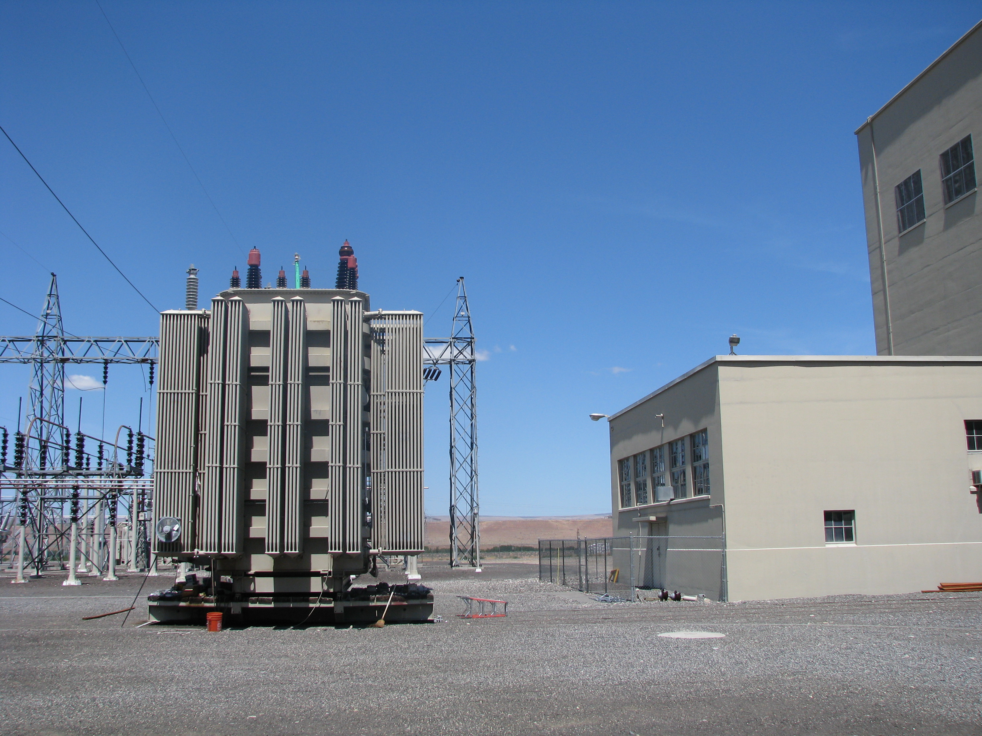
Switchyards are, in general the “works” of a substation, and feature a complex arrangement of individual elements that function collectively as a part of the system. Switchyard sites are generally characterized by a vertical superstructure of steel, typically latticework, with conductor, circuit breakers, insulators, transmission towers, and other electrical equipment connect incoming and outgoing transmission lines to a series of grade-mounted transformers, circuit breakers, switches and other equipment. In general, switchyards are “designed to control power flow and transform voltages for distribution (Curran 1998:111),” and then feed low voltage distribution and/or high voltage transmission lines out of the complex.
Originally installed in 1941, the Switchyard is flat, covered with crushed rock, and bounded by a metal chain-link fence (Z-8814) with access to the north. The Switchyard includes three current transformers, three small oil and five gas circuit breakers below a dead-end tower surrounded by buswork, and three large power transformers with adjacent transformer radiators to the south, and a long row of two potential transformers, six current transformers, and six gas and 42 oil circuit breakers under three dead-end towers surrounded by buswork to the north.
The switchyard also includes its original transformer track (Z-0000) with cart, a rectangular metal paneled engine generator building with a low pitched front-gabled roof (Z-554), a horizontal oil tank, six original vertical oil tanks atop a slab-on-grade concrete foundation with short concrete retaining wall, as well as multiple small square-shaped metal storage and oil absorbent sheds and concrete paths throughout.
Moderate alterations to the Switchyard have occurred since its original installation, according to a field investigation completed June 29, 2017 as well as an analysis of aerial images and historic documentation. Changes to the plan include its extension to the east circa 1948 (BPA) and west circa 1964 (BPA Aerial 1964). Other changes to the Switchyard include the addition of two new power transformers circa 1945 and the removal of two by 1958 (BPA Aerial 1958), the installation and removal of capacitor housing in 1949 (BPA) and their removal circa 1964 (BPA Aerial 1964), the construction of the condenser by 1958 and its removal circa 1981 (BPA Aerial 1981), new gas circuit breakers to the south of the transformer circa 2004 (BPA Aerial 2004), and the removal of one of the original four power transformers circa 2009 (BPA Aerial 2009). Gas circuit breakers started to replace original oil circuit breakers starting in 1992 (BPA Aerials 1992-2013).
Bend Bulletin. 1958. “Contract Award Made to Firm.” July 30. Bonneville Power Administration (BPA Aerial). Various dates. “Aerial photos 1954-2007.” Copies on file at Bonneville Power Administration of Multnomah County, Portland, Oregon. Bonneville Power Administration (BPA). “2016 Facility Condition Assessment,” VFA Facility Database, 2016. https://facility.vfafacility.com/facility/frameworks/main.jsp. Accessed 5/11/2017. Bonneville Power Administration (BPA). 1939. Second Annual Report of the Administrator of the Bonneville Power Administration. United States Department of the Interior. Bonneville Power Administration (BPA). 1941. Annual Report of the Administrator of the Bonneville Power Administration to the Secretary of the Interior. U.S. Department of the Interior. Bonneville Power Administration (BPA). 1944. Annual Report of the Administrator of the Bonneville Power Administration. U.S. Department of the Interior. BPA.gov. 2017. About Us. Electronic Document, https://www.bpa.gov/news/AboutUs/Pages/default.aspx (accessed March 29, 2017). Curran, Christine Ann. 1998. Master’s Thesis. A Historic Context for the Transmission of Hydroelectricity by the Bonneville Power Administration, 1939-1945. University of Oregon. Daily Capital Journal. 1941. “Raver Orders Speed-up In Line Building.” December 17. Department of Archaeology and Historic Preservation (DAHP). 2011. Midway Substation. Property ID 102474. Historic Property Report. Holstine, Craig and Gloria J. J. Lenz. “Bonneville Power Administration Master Grid Discontiguous Historic District.” National Register of Historic Places Registration Form. Washington, D.C.: U.S. Department of the Interior, National Park Service, 1986. Idaho Statesman. 1951. “Third Power Line Will Strengthen Northwest’s Pool.” December 28. Kramer, George. 2010. Corridors of Power: The Bonneville Power Administration Transmission Network. Historic Context Statement. For the Bonneville Power Administration, Portland, Oregon under Master Agreement #38010. April. Kramer, George. 2012. Bonneville Power Administration [BPA] Pacific Northwest Transmission System. Multiple Property Documentation Form. National Park Service. United States Department of the Interior. Lally, Jessica. 2009. Midway Substation, Historic Property Report. Department of Archaeology and Historic Preservation, Washington. Citing White, Richard. 1995. The Organic Machine: The Remaking of the Columbia River. Harper Collins Canada Ltd. National Park Service (NPS). 1997. “How to Apply the National Register Criteria for Evaluation,” National Register Bulletin. U.S. Department of the Interior, National Park Service. Oregonian. 1941a. “Raver Orders Step-up For Bonneville Work: New Cash Anticipated.” December 17. Oregonian. 1941b. “Transformer Bid of $272,202 Low.” July 4. Oregonian. 1944. “WPB Okehs Line For Bonneville.” August 18. Oregonian. 1949. “Raver Lists BPA Projects.” October 13. Statesman Journal. 1941. “Bonneville Setup To Get $7,000,000.” January 11.
Statement Of Significance
Properties associated with energy development, specifically the establishment of the BPA Master Grid, are historically significant because of the role such properties have played in the history of the Pacific Northwest (Holstine, 1988; Kramer 2009). Much of the development and industry of Washington State has ties to the history of energy development, particularly that which is associated with Columbia River hydroelectricity and its supporting energy transmission infrastructure.
Championed by Franklin D. Roosevelt, the development of hydroelectricity was undertaken in order to harness this vast and undeveloped resource in the Pacific Northwest region (Holstine, 1988), thought to contain nearly half of all hydroelectric power available to the United States (White, 1995). It was believed that the entire future of the Pacific Northwest was directly linked to, and dependent upon, the development of the Columbia River (Bonneville Power Administration, history).
Roosevelt and the United States Congress approved funding and construction of major hydroelectric development within Washington and Oregon, beginning with Bonneville Dam and Grand Coulee Dam in 1933 (Bonneville Power Administration, history). Not long after the completion of the Bonneville Dam, the Bonneville Project Act, later renamed the Bonneville Power Administration (BPA) (White, 1995), was approved by Congress with the intent to grant the BPA the authority to establish an electrical transmission system for the distribution of hydroelectric power generated by the dams (Holstine, 1988).
Commencement of transmission line construction began in 1938, and with each subsequent transmission line completion, the BPA power grid grew larger, connecting more hydroelectric power with portions of Washington State. This interconnected power grid became known as the BPA Master Grid, and the push for its creation was largely based on concerns for national security (White, 1995). Construction work on BPA lines provided jobs during the Depression, specifically for the Works Progress Administration workers who prepared areas where lines and substations were to be erected (Holstine, 1988).
Later, the electrical generation and transmission of the BPA substations and lines would play a significant and critical role in the United States efforts during World War II (WWII) by providing electricity needed for aluminum and atomic development (Holstine). Beyond opening the region to development and industry, providing jobs during the Great Depression, and enabling atomic development through the provision of electricity, energy development has forever altered our natural and cultural history. It has, in essence, shaped the modern Pacific Northwest.
The Midway Substation was built as part of the BPA Master Grid and was a critical link in connecting the Bonneville and Grand Coulee into a single system (Holstine, 1988). It is as a part of the BPA Master Grid, which was nominated to the NRHP by Holstine in 1987, that the Midway Substation has a great deal of historical significance. Kramer (2009) also attaches significance to such resources, noting the eligibility of those properties associated with the BPA Transmission Network. However, the Midway Substation also has historical significance outside its direct association with the BPA Master Grid. In fact, the Midway Substation played a critical role in plutonium production through provision of electricity to the Hanford Atomic Works, which ultimately enabled the development of the atomic bomb dropped on Nagasaki at the close of WWII (White, 1995). Kramer (2009) suggests that a substation, given that it retains sufficient integrity, may be considered eligible to the NRHP as they constitute a portion of the larger BPA Transmission Network.
As a portion of the BPA Transmission Network, and built as a portion of the original BPA Master Grid, the Midway Substation is a property that has contributed to the broad patterns of national and regional history, carrying with it associations with industry, specifically atomic development during WWII, and federal development of public power in the Pacific Northwest. Given that the Midway Substation does appear to have sufficient integrity to convey its historic significance, it is our recommendation that the Midway Substation is eligible under Criterion A for listing in the NRHP.
Although this recommendation is based largely upon the buildings constructed in 1941, eligibility may be extended to those built at a later date. This recommendation is justified in that the property is part of the inter-related BPA Network and a portion of the cohesive system. Therefore, the Criterion G exception for buildings less than 50 years old is applicable.
The Midway Substation consists of eight separate buildings built between 1941 and 1990. The two primary buildings, constructed in 1941, include the control house and the untanking tower, built from reinforced masonry. Additional buildings include the following: two battery buildings, constructed in 1990; an engine generator building, constructed in 1975; a flammable storage unit, constructed in 1979; an additional storage unit, constructed in 1975; and a shed, constructed in 1985. The control house is a two-story building with a rectangular floor plan, with cast in place reinforced concrete basement walls and wall-footing foundations. The roof of the building is flat, consisting of steel bar joists with a tongue and grove wood deck. The untanking tower appears to be of similar construction with a few notable differences. The building is single story, with a reinforced concrete foundation and painted concrete exterior walls.
Bonneville Power Administration, history (n.d.) retrieved online October 30, 2009 from http://www.nwcouncil.org/history/BPAHistory.asp Brannan, N., personal communication, October 30, 2009 Holstine, C., (1988) Power to the people: Construction of the Bonneville Power Administration’s ‘Master Grid’, 1939-1945. The Pacific Northwest Forum, Second Series, Volume I, Number 2, pp 35-46. Kramer, G., (2009). Corridors of Power: the Bonneville Power Administration Transmission Network Historic Context Statement. Prepared for the Bonneville Power Administration. Portland, OR. White, R., (1995). The organic machine: the remaking of the Columbia River. Harper Collins Canada Ltd.
Inventories
|
10/20/2009 |
Current Status: Review Complete
3.0.22


