Slide show I wrote up for the Great Northern Railway Historical Society annual convention in Nelson, BC.
The as-built view of the bridge at Marcus over the Columbia River. The bridge was constructed in 1901 entirely of wood. Marcus was where the line from Spokane split, with one branch going on to Grand Forks, Oroville, and eventually Vancouver, BC. The other branch went along the Columbia River, crossed into Canada, and eventually ended at a place called Nelson.
Ice floes and high water along the Columbia in February 1929 severely damaged two spans. During the floe, pier number 5, near the center of the river, started to move downstream during one of the worst ice jams yet experienced in the river at that point. The pier continued to move a few inches a day, until it had gone downstream 22 feet and had settled 20 feet on one corner. The spans were badly twisted when the movement of the pier finally stopped.
Plans called for a new bridge 100 feet upstream from the old structure. Three of the wooden spans would be retained, a fourth wooden span would be rebuilt, and three new steel spans of 225 feet each would be used.
A short timber approach would be required on the south side, and a trestle approach 700 feet long would be required on the north side
During March 1930, during the construction of the new bridge, fire broke out and soon both bridges were burning. Losses at the time were estimated at $150,000. Three wooden spans had just been moved into place from the old structure, all of which were consumed. One new steel span dropped into the river. The trestle approach on the north side burned. The small fire fighting crew from Marcus were joined by forces from Orient and Colville. The new bridge was supposed to have reopened within a week.
The GN mustered it's forces and completed the bridge in by April 1930. Shortly after the new bridg opened, spans of the old bridge were dynamited out of the way.
John Barriger III took this photo of the bridge in 1939, looking north. Notice the the approach and fill on the far side.
John Barriger III took this photo as well, looking south towards Marcus proper. Notice the two wooden spans on this end of the bridge.
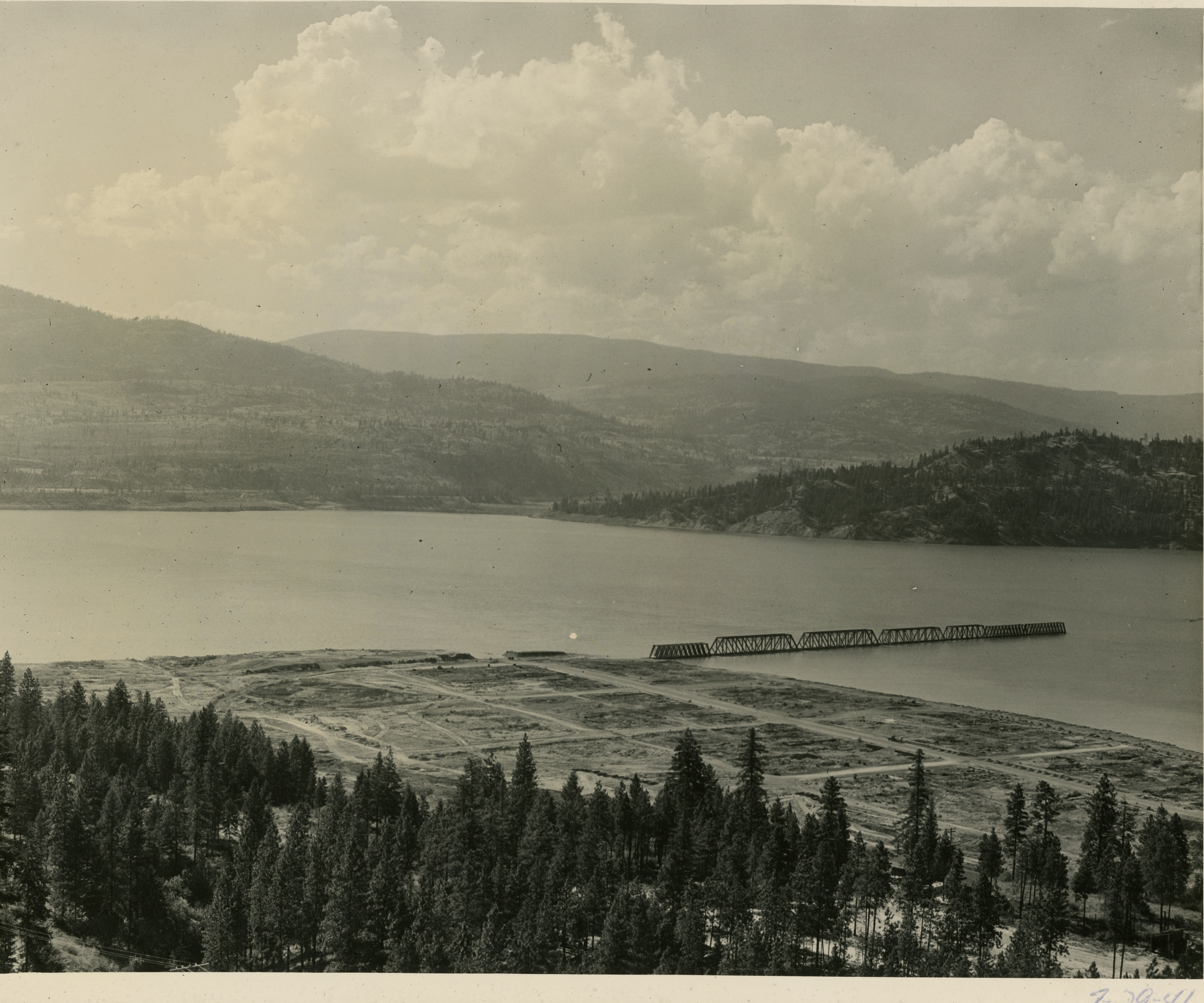
The caption on the bottom reads: “Air photo of the old and new Marcus, looking northward (NE). At a point above the southern part of old Marcus (in the lower right of the photo), the evacuation town is seen below the bench on which new Marcus is developing. Long street in center is Main Street. Lower long line on hillside at right is the new highway in the building and above, the new railroad.
Eric Jacobson sent along this photo, possibly taken around 1938 or 39, of his grandfather and his stepfather on the bridge.
Springtime runoff on the Columbia River was being impounded by a rising Grand Coulee Dam downstream, with the result being the river rose to an unprecedented height at the time of this photo, on July 29, 1941. By now the entire town has been removed and the bridge is being inundated.
Another July 29, 1941 view of the bridge, this time from water level. All the rail has been removed and the trestle and fill approach on the far side are under water.
Water has receded in this February 1942 view. Approaching the bridge from the left is the powered barge “Paul Bunyon” which is pushing another barge in front of it. You can see the north approach from the bridge again above the water level, as well as part of the grade and wye in the foreground. Why is this happening? A severe building material shortage is gripping the nation, and these sections of bridge are going to be salvaged for building projects around Grand Coulee Dam.
Things are getting interesting here. The empty barge is being partially sunk, to fit under one of the spans. The Paul Bunyon will push it into place. In the meantime, workers will be loosening any fittings tying the span to the pier.
Water is pumped out of the barge, lifting it and the span of the bridge. Note the high water mark of the water on the bridge.
One span is on it's way to Grand Coulee! Pushing this time are the boats “Camp Ferry” and “Blue Ox.” Every section of the bridge was removed this way. In fact, the GN realized it needed to retain one of the sections and paid the Bureau of Reclamation $10,000 for it. It was used at the bridge at Waneta, where there was a crossing of the Pend Oreille River.
March 1942 marked the final part of the bridge removal, detonating the remaining piers. Twelve hundred pounds of powder were used to blast one of the Marcus bridge piers loose from its foundation. The water spout is about 40 feet high from the water level. Most of the powder in this shot was about 35 feet below the water surface.
Bridge removing operations continued just up the Kettle River from Marcus. Here we see a June 1942 view of the Paul Bunyon again with a barge being placed under a bridge section near Boyds.
Same scene as the previous slide.
Floating the sections were a bit more tricky on the Kettle River. Not seen in this view is the Paul Bunyon holding the barge in place while the tugboat “Nespelem” helps navigate around a bend.
Just a bit further down the Kettle from the last view, we can see the the Paul Bunyon anchored behind a spit of land while the Nespelem continues to turn the bridge section.
Both the Nespelem and Paul Bunyon move a bridge section under the new railroad and highway bridges at the mouth of the Kettle River.
Same as previous.
Now clear of the Kettle River, the Paul Bunyon is used to better turn the barge in the growing body of water and the confluence of the Columbia and Kettle Rivers.
Satellite view of the bridges over the Kettle River confluence with the Columbia River today.
A smaller section of bridge is being moved just downstream from the new railroad over the Kettle, about 2 1/2 miles north from the confluence with the Columbia, and about 1/2 mile south of where the old bridge crossed.
Satellite view of where the new bridge seen in the previous view was located.
The smaller section of bridge previously seen moving into the open water of the Columbia River at the Kettle River confluence.
A larger bridge section arriving behind Grand Coulee Dam. The Paul Bunyon is pulling while the Camp Ferry is on the opposite side of the bridge.
Closer view of the bridge section and the Paul Bunyon. Part of the town of Grand Coulee can be seen in the distant right side.
A bridge section has been beached and will soon be building material. In the background is the town of Grand Coulee.
One bridge section is being taken apart.
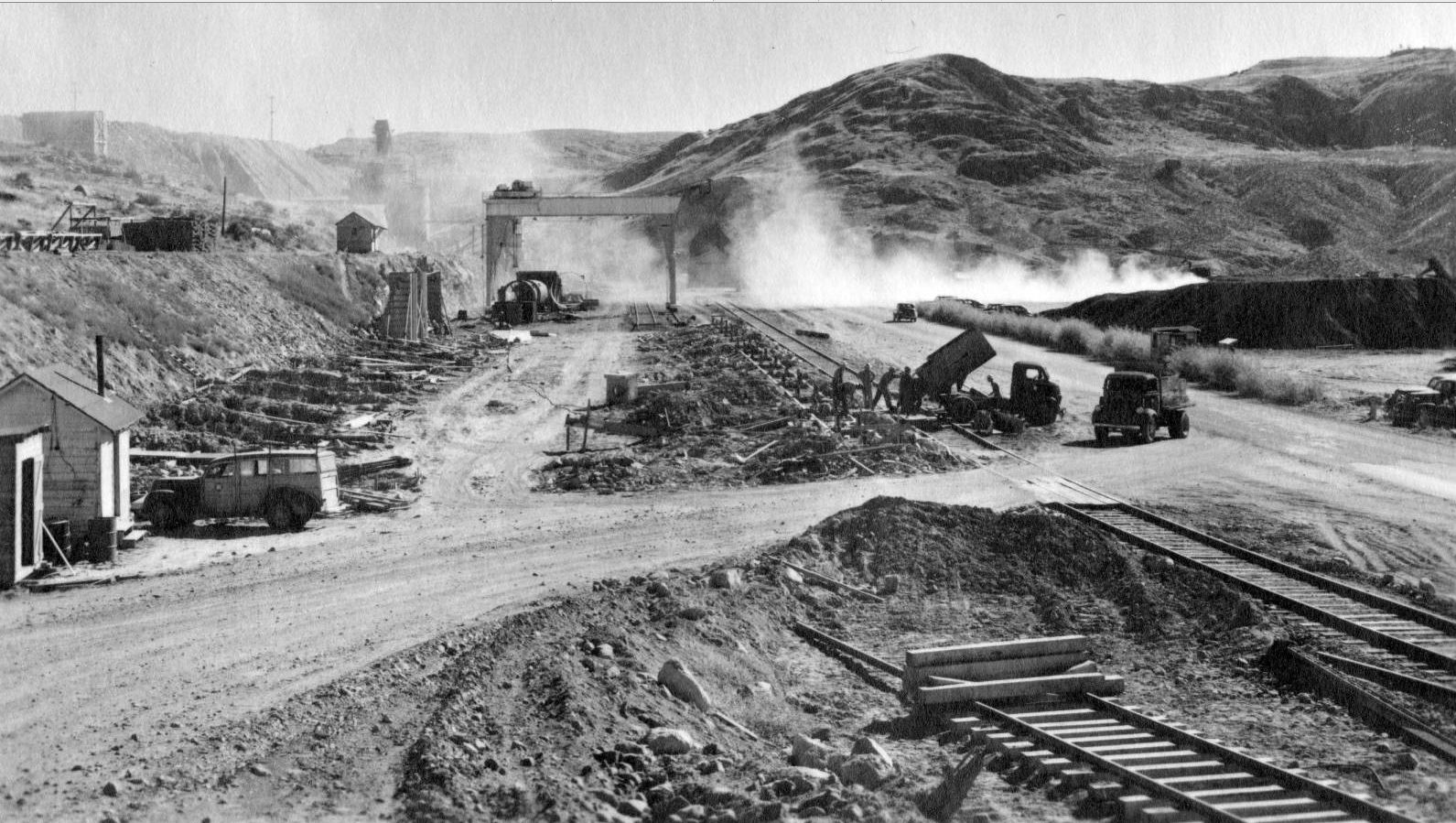
This is the site of the cement unloading facilities just southwest of the Grand Coulee Dam site. Note the tracks in the background. The need for a large building to hold material for construction will be built here.
The site for what will be known as the Assembly building is being prepped. The cement tanks can be seen through the dust on the left of the 75 ton gantry crane, which had been relocated from the Electric City yard.
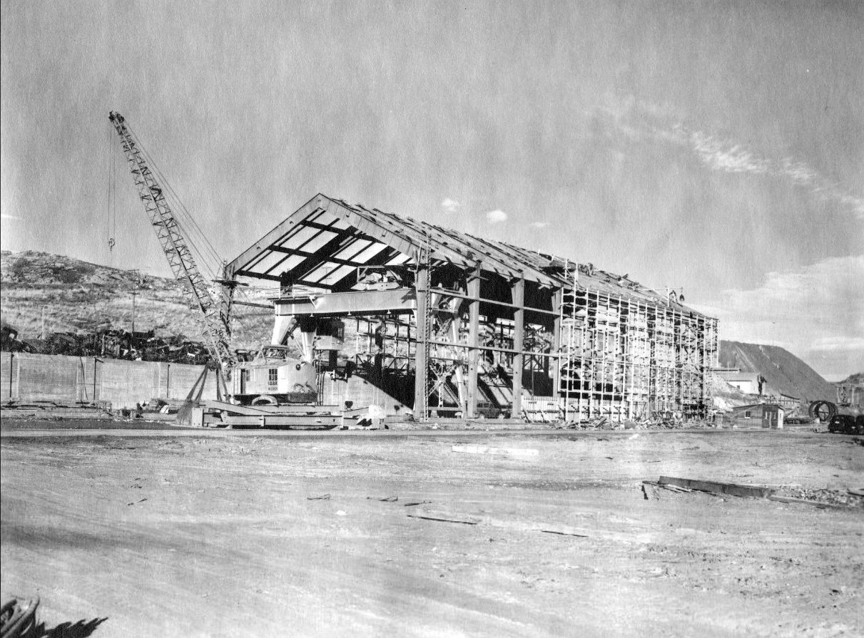
The first of the trusses are going up for the Assembly Building. Reclamation engineers notes that “columns in Bents 1, 2 and 15 are made of small members (19" deep) from 225' bridge” and “columns in bents 3 to 14 inclusive are made of large members (21" deep) from 253' bridge.” The walls are about 45 feet tall, the width about 77 feet, and is 355 feet long. The gable of the roof is 65 feet above grade.
The building is nearly complete. You can see the bridge girders all along the roof supports. The gantry crane previously seen is now part of the interior of the building.
The opposite side of the building. Note how the cement tanks are now gone. The road in the bottom of the view leads to the dam toward the right.
View of the completed building. Note it's proximity to the completed Grand Coulee Dam.
Current view of the building. Most of the other buildings in this view are newer construction. Thanks to John Kemble for snagging the photo.
Where the building sits today in the industrial complex that supports the dam. SR 155 curves around the right side of the site.
Other buildings constructed with salvaged bridge material material no longer stand. Some started to be torn down in the 1960s. This building once stood near where the current visitor's center is. It too had bridge members as trusses.
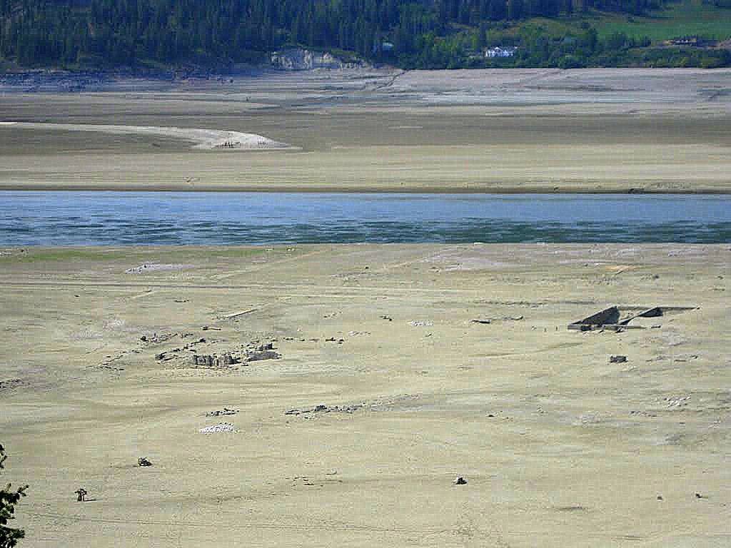
A look back at Marcus in 2011 when the water behind Grand Coulee Dam was lowered considerably, the northern approach to the old Marcus bridge popped out of the water. Many foundations of the old town can be seen regularly even today.
Satellite view of what the Marcus townsite normally looks like today. The railroad can be seen as the line through eh trees below the yellow line of SR 25.
Of the 2 current trusses of the bridge over the Pend Oreille River at Waneta, are either one from the Marcus bridge?


2 comments:
Really interesting. If one of the Marcus spans is at Waneta, it's the one on the left. However, I did not think it was in place until 1947, so where would it have been stored for five years? The bridge on the right was built in 1893, originally as a railway bridge, and converted to a highway bridge in 1947. It's now the oldest bridge in BC.
I'm still looking for the AFE that speaks to the span replacement. So, I can't say for certain at this time.
Dan
Post a Comment